
Ideas: The Research Agenda — Service to Society
 The
provision of reliable information on geophysical phenomena, both natural
and human- influenced, that is well-targeted to meet societal needs is
a significant product resulting from geoscience research. Losses in the
United States from geophysical disasters have risen rapidly. Single extreme
events, such as hurricanes, tornadoes, earthquakes, volcanic eruptions,
solar storms, and floods can cause losses of several billion dollars and
severely disrupt commerce and daily human activity. The cumulative effects
of less dramatic conditions in the environment, such as drought, erosion,
long-term changes in climate, and pollution can be equally devastating.
The
provision of reliable information on geophysical phenomena, both natural
and human- influenced, that is well-targeted to meet societal needs is
a significant product resulting from geoscience research. Losses in the
United States from geophysical disasters have risen rapidly. Single extreme
events, such as hurricanes, tornadoes, earthquakes, volcanic eruptions,
solar storms, and floods can cause losses of several billion dollars and
severely disrupt commerce and daily human activity. The cumulative effects
of less dramatic conditions in the environment, such as drought, erosion,
long-term changes in climate, and pollution can be equally devastating.
It should be recognized that reliable information also provides many positive opportunities. Short-term weather forecasts are of inestimable value in many businesses; projections of El Niño provide opportunities to well-informed organizations and economic sectors; advanced characterization of soils and surface conditions provides critical inputs for agricultural and hydrological interests; and knowing ground conditions permits estimates to be made of potential earthquake severity which lead to improved construction techniques.
We recognize that our basic societal infrastructure is becoming more fragile in many ways. Population is becoming increasingly geographically concentrated, and the nation's susceptibility to significant geophysically induced disruption is increasing at an alarming pace. For example, the increased connectivity of long-line power networks has heightened the probability of massive power blackouts due to geomagnetic storms. With accurate prediction, power can be rerouted and such enormously disruptive events averted. The nation's increasing reliance upon surface and air transportation for moving people and massive quantities of goods, coupled with these systems' sensitivity to weather, has created similar vulnerability to severe local storms. Accurate predictions will allow for contingency rerouting and rescheduling. The infrastructure of many U.S. urban areas, especially in California and the Pacific Northwest, is exposed to significant earthquake and volcanic risk. Urban and rural areas along the nation's waterways and coasts are vulnerable to floods, hurricanes, and erosion. In all of these cases, substantial human and property losses can be reduced through reliable warnings based on fundamental understanding.
 Geophysical
hazards are not exclusively natural. Hazards can be created or amplified
through ill-advised human impacts on the environment, such as inappropriate
use of land and water, waste disposal, deforestation, and exploitation
of geological resources.
Geophysical
hazards are not exclusively natural. Hazards can be created or amplified
through ill-advised human impacts on the environment, such as inappropriate
use of land and water, waste disposal, deforestation, and exploitation
of geological resources.
By linking basic science, engineering, public policy, and economics, it is possible to develop infrastructures that mitigate the impact of both natural and anthropogenically induced hazards. Rational policymaking and planning are critical in reducing risks to an increasingly complex global society. Fundamental geoscience information is an essential underpinning for developing rational policies and plans to protect infrastructure in areas at risk.
Providing the observations and information systems necessary for assessment and monitoring of hazards greatly exceeds the capabilities of single agencies or even single nations. Within the U.S., there are opportunities to develop and improve coordination between the NSF, mission agencies, and non-governmental entities. In many parts of the world, population and its associated infrastructure continue to grow where there is minimal information on the potential impact of natural hazards. As a leader in an ever-more-integrated global society, it is in the economic and strategic interests of the U.S. to participate in the monitoring, research, and planning necessary to reduce global vulnerability to hazards.
The Earth sciences have a long tradition of international cooperation in data collection and research. The global scale of environmental problems, as well as the global nature of current and future observing systems, make international cooperation not only logical and feasible but essential.
PREDICTION OF HAZARDOUS EVENTS
![]()
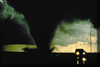
Weather Extremes
and Related Hazards
Extreme weather
events are among the most pervasive of all hazards in the geosciences,
routinely impacting national and international commerce, transportation,
defense, energy, and communications infrastructures. Indeed, on average
the U.S. economy loses more than $300 million per week because of such
events, and in many industries much of this loss could be prevented with
more accurate and timely warnings.
During the past two decades, and in particular the last several years, significant advances have been made in understanding and predicting atmospheric phenomena on scales ranging from planetary waves to individual thunderstorms. Today's 72-hour operational forecasts are as accurate as 36-hour forecasts were 20 years ago, and new observing systems such as the NEXRAD Doppler radar have more than doubled the warning time for tornadoes. The capability of predicting the evolution of events, such as El Niño, which impact much of the globe has now been demonstrated, and the expectations of society are increasing proportionally.
The provision of more accurate weather prediction culminating in the transfer of associated decision-making information to the user community is a central goal of the atmospheric sciences. To meet that challenge, a number of key scientific and technological topics must be addressed: the structure of hurricanes from genesis to decay; the quantitative prediction of precipitation type, intensity, onset, duration, and location; the fundamental predictability of mesoscale and storm scale weather; the role of the land-surface in driving small-scale atmospheric processes; the influences of orography and coastlines at several scales; the appropriate mix and assimilation of observations for use in numerical forecast models; the development of physically realistic and complete parameterizations for forecast models; the effective utilization of new computing and communications technologies; and the conversion of meteorological data into useful decision- making information.
Progress in these and other areas, aided in part by the organizational framework of the weather research programs and the coordinated involvement of many agencies, will lead to significant improvements in the nation's predictive capabilities, thereby increasing the time available for effective response to weather hazards and concomitant savings in human life and property.
Geological
Threats
 The Earth evolves:
its solid surface – terra firma – changes through unrelenting forces of
internal deformation from below and erosion from above. The cumulative
effect of these processes builds and destroys mountains over the eons
of geological time. On the human time scale, the agents of change – earthquakes,
volcanic eruptions, and landslides – pose direct threats to society. To
reduce these threats, fundamental knowledge about the processes that drive
these changes and the nature of individual events is essential.
The Earth evolves:
its solid surface – terra firma – changes through unrelenting forces of
internal deformation from below and erosion from above. The cumulative
effect of these processes builds and destroys mountains over the eons
of geological time. On the human time scale, the agents of change – earthquakes,
volcanic eruptions, and landslides – pose direct threats to society. To
reduce these threats, fundamental knowledge about the processes that drive
these changes and the nature of individual events is essential.
While these events are not as frequent as weather disasters, human populations and managed environments are especially susceptible to their impact because of their abrupt onset and concentrated areas of damage. Improved knowledge of the spatial and temporal characteristics of earthquakes and volcanic eruptions will help in defining long-term hazards in areas of moderate to high tectonic activity. Increased understanding of the ground motions produced by large earthquakes will contribute to improve engineering design for safer structures. Recent destructive earthquakes have dramatically shown that damage in urban areas is strongly controlled by local ground conditions. Earth scientists, working closely with engineers and urban planners, can use their knowledge of the earthquake source, wave propagation, and local geology, and their ability to probe shallow surface layers, to predict the influence of strong events on the excitation and amplification of ground motions. Progress is essential in understanding faults, rupture growth, and their evolution into major earthquakes as well as the role of rheology, heterogeneity, and randomness.
Ecological Hazards
Biological invasions
have become commonplace in virtually all habitats of the Earth system.
However, the extent to which the unintended introduction of exotic (non-indigenous)
species has impacted many ecosystems is unknown. Invading species, for
example, have profoundly altered many coastal ecosystems. Introductions
may bring together species with no co-evolutionary history, and thus introduced
species may proliferate free from natural biological controls. Such invasions
can lead to profound changes in community structure and food web dynamics
and ultimately may affect overall species diversity and the complexity
of ecosystem function in Earth systems. Ecosystem changes brought about
by invasions are generally very different and often much greater than
natural changes in biodiversity and in complex ecosystem processes.
Proliferation of microscopic algae in coastal systems can cause massive fish kills, contaminate seafood with toxins, alter ecosystems in apparently harmful ways and potentially kill people. Seaweed proliferation, often of a single species, can overgrow and disrupt natural coastal systems such as coral reefs. Although harmful algal blooms (HAB) occurred long before human activities began to transform coastal ecosystems, a survey of affected regions and of economic losses and human poisoning clearly suggests that there has been a dramatic increase in the worldwide impacts of HAB. Our ability to describe the factors controlling the dynamics of individual HAB species is constrained by critical gaps in knowledge about how the physiological, behavioral, and morphological characteristics of HAB species respond to environmental conditions.
Space Weather
Hazards
"Space weather"
refers to conditions on the Sun and variations in the solar wind, magnetosphere,
ionosphere, and thermosphere. Space weather hazards can influence the
performance and reliability of space-based and ground-based technological
systems and can endanger human life and health. For example, adverse conditions
in the space environment can cause disruption to satellite operations
and electric power grids. Most new and planned satellites are planned
for lower orbits than those of the past and are designed to make use of
cheaper "off the shelf" electronic components rather than radiation-hardened
components. As a result, these satellites are more susceptible to space
weather. Satellite systems like the Global Positioning System (GPS) will
be part of extended "constellations," interacting with each other in complex
ways. More than 1500 space payloads are forecast to be launched over the
next ten years. Many risks to these systems that may be impacted could
be mitigated or avoided if accurate space weather forecasts and reliable
quantitative models were available for use in system design and deployment.
The Primary Challenges
There are ten primary research challenges in the area of prediction of hazardous events:
- determining the fundamental limits of predictability and the applicability of stochastic and dynamic methodologies;
- improving the understanding of coupling among the Earth system components, and developing coupled/integrated models to enable more physically realistic and accurate predictions;
- advancing the understanding of meteorological and hydrological processes that lead to extreme weather conditions;
- understanding the fundamental processes of plate boundary interactions, earthquake generation, and volcanic eruptions;
- understanding the relationship between environmental conditions and the physiological, behavioral, and morphological characteristics of harmful algal bloom species;
- developing an improved predictive capability for the global geospace environment, enabling protection of technological systems from damaging space weather events;
- providing adequate data gathering capabilities at the temporal and spatial scales required to understand and predict human-induced and natural hazards;
- ensuring adequate computational and communications capabilities;
- ensuring effective monitoring and transition of research into operations through collaboration among agencies; and
- increasing public awareness of the impacts of natural and human-induced hazards and mitigation capabilities.
ASSESSMENT OF ENVIRONMENTAL QUALITY
![]()
One of the challenges
facing modern societies is to prevent further inadvertent degradation
of environmental quality caused by local, regional, or global growth in
population and technology.
Air Pollution
Air pollution and
its impact on human health and ecological systems is a major societal
concern. The lower atmosphere can oxidize both industrial and biological
emissions of pollutants. Precipitation and/or dry deposition removes the
resulting fully or partially oxidized pollutants from the atmosphere relatively
rapidly. The maintenance of this self-cleaning "atmospheric oxidative
capacity" is critically important to sustain a healthy environment. However,
unfavorable meteorological conditions can render atmospheric oxidative
processes ineffective or even destructive. The resulting airborne concentrations
of partially oxidized pollutants and oxidizing intermediates can have
both acute and chronic detrimental impacts on human health, agricultural
productivity, and natural ecosystem sustainability. The future build-up
of populated and industrialized regions and a potentially warmer climate
may combine to create these highly undesirable atmospheric conditions,
both more frequently and over much larger areas, in the future. Understanding
the basic chemical and physical processes that define the capacity of
an airshed to maintain acceptable air quality remains a high priority.
Water Quality
 The
availability of high quality fresh water for societal uses is emerging
as the most likely limit to activities in many regions of the world. Managing
water quality and the availability of water resources will be one of the
most serious environmental challenges facing local, regional, national,
and international policy makers in the decades to come. Effective management
of ground and surface water resources requires an understanding of hydrologic
systems and factors that determine the distribution, availability, and
quality of water. These systems often involve complex biological habitats
such as wetlands, watersheds, lakes, aquifers, and tropical rainforests.
Each of these systems operates at multiple space and time scales and couples
physical, chemical and biological aspects. A major new systems-based,
interdisciplinary framework for research and education is needed to build
a fundamental understanding of hydrologic systems for effective future
water management and protection.
The
availability of high quality fresh water for societal uses is emerging
as the most likely limit to activities in many regions of the world. Managing
water quality and the availability of water resources will be one of the
most serious environmental challenges facing local, regional, national,
and international policy makers in the decades to come. Effective management
of ground and surface water resources requires an understanding of hydrologic
systems and factors that determine the distribution, availability, and
quality of water. These systems often involve complex biological habitats
such as wetlands, watersheds, lakes, aquifers, and tropical rainforests.
Each of these systems operates at multiple space and time scales and couples
physical, chemical and biological aspects. A major new systems-based,
interdisciplinary framework for research and education is needed to build
a fundamental understanding of hydrologic systems for effective future
water management and protection.
Healthy environmental conditions are also essential for sustaining coastal and marine ecosystems, commercial and recreational fisheries, and economic growth in coastal communities. The health of coastal and marine ecosystems is affected by water quality, and in turn, water quality is dependent upon ecosystem health. Despite their value and the programs in place designed to protect them, many coastal waters are still being degraded at an alarming rate. Much about the ocean, its processes, and the interrelationship among land, sea, and air is poorly known. Continued fundamental research on processes affecting coastal systems is needed so that sound management decisions can be made. Although much progress has been made over the past 30 years to enhance marine environmental quality and protect ocean resources, fundamental research is still required.
Soils
Soils control land
surface albedo and act as a porous medium for water storage and movement.
They are the sites of mineralization and provide nutrients which control
plant growth. They determine the rates of decomposition, carbon storage,
moisture availability, trace gas production, and nutrient supply. Consequently,
the condition of soils is a critical element in the maintenance of environmental
quality.
The Primary Challenges
Pressing questions that will need to be addressed to better understand the natural and human- induced processes that affect and control environmental quality include:
- determining how the physical, chemical, geological, and biological processes that comprise the Earth's natural systems are functionally interrelated. Environments of interest are the lower troposphere, groundwater, surface waters, coastal marine and estuarine areas, and soils;
- defining the oxidizing capacities of airsheds on a variety of space and time scales;
- understanding how biological processes contribute to environmental sustainability, deterioration, or improvement;
- understanding the hydrologic (and related land and air) processes that determine water quality and its vulnerability to degradation;
- ascertaining the coastal ocean (and related land and air) processes that define environmental quality and vulnerability;
- defining the processes which control the condition of soils and understanding the factors which contribute to soil degeneration and renewal.
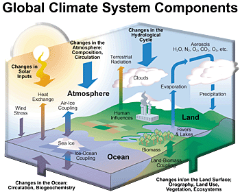
PREDICTION OF LONGER-TERM CHANGE AND VARIABILITY
![]()
The Earth is constantly
changing on all scales of time and space. Although the short-term hazards
discussed above have the most immediate impact on daily activity, there
is growing realization that longer-term variability due, for example,
to natural and human-induced changes in atmospheric composition, water
resources, coastal structures, and landforms, may have even more profound
impacts on society. El Niño events, the drought of the 1930s, and the
Northeast ice storms of 1998 provide ample evidence of the importance
of climate variability on human activity. Current models project that
activities such as fossil fuel burning and changes in land use will have
significant climatic impacts. Natural variations in and human depletion
of aquifers can inhibit or even destroy agricultural productivity and
reduce the availability and quality of water for human consumption. Deforestation
impacts both climate, via photochemical processes, and landforms, through
erosion. The potential impact of these and other changes spans the full
spectrum of human interests, from agriculture, fisheries, water resource
availability, water quality, transportation, and energy production and
utilization, to ecosystem viability and human health.
Seasonal to Interannual Variability
Research on seasonal-to-interannual
climate variability has entered a new age with the recent prediction of
the evolution of the El Niño - Southern Oscillation (ENSO) many months
in advance. The success of the El Niño forecasts set the stage for other
major advances on seasonal-to-interannual time scales. In particular,
we are poised to make significant advances in understanding the variability
of the monsoons, determining the role of land-surface and atmospheric
moisture and energy exchanges in governing variability, downscaling climate
predictions for improved regional assessments, and incorporating terrestrial
hydrology into predictive models.
Longer-Term Variability
The historical and
paleoclimatic records contribute strong evidence of variability on decadal
to century time scales, including abrupt climate transitions on time scales
of one to ten years. Tree rings, ice cores, corals and lake sediments
provide a rich record with the potential to help define the nature of
global and regional variability. These longer records help define the
nature of the sensitivity of the coupled Earth system. Remarkable progress
has occurred over the last decade in developing coupled Earth system models.
These models, constrained by global-scale observational records, are helping
to document the mechanisms of Earth system variability.
As we begin to include additional major components of the Earth system in coupled and integrated models, unique opportunities will arise to assess predictability over a wider range of time and space scales. Currently, interest is focused on the regional impact of climate change over the next few decades and the possibility of abrupt climate change.
The Primary Challenges
Challenges to expanding our capability to predict changes in the Earth system include:
- developing a more complete understanding of the key processes responsible for longer- term change and variability in the Earth system and concurrently developing more accurate physical parameterizations for simulation models;
- ensuring adequate computational and communications capabilities;
- establishing adequate baselines that specify the present conditions of the Earth system and developing links with the geological record of Earth's past environment; and
- providing adequate data-gathering capabilities to understand long-baseline global-scale changes in Earth systems.
![]()
![]()