
Multimedia Gallery
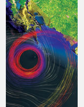
Visualizing Hurricane Katrina
Visualizing Hurricane Katrina
A four-member team at the Center for Computation and Technology (CCT) at Louisiana State University used supercomputing to create a complete three-dimensional picture of Hurricane Katrina showing multiple elements and integrating data from many sources.
CCT is part of several initiatives that are using supercomputers to perform simulations of tropical storm and hurricane events such as Hurricanes Katrina and Rita, two storms that devastated Louisiana and the northern coast of the Gulf of Mexico, in order to better understand the science of storms and ensure more accurate predictions in the future. To learn more about this research, visit the project's Web site at http://www.cct.lsu.edu/projects/sc05/index.php. (Date of Image: October 2005)
Credit: LSU/CCT/Werner Benger, Amanda Long, Shalini Venkataraman, Stephen David Beck
Images and other media in the National Science Foundation Multimedia Gallery are available for use in print and electronic material by NSF employees, members of the media, university staff, teachers and the general public. All media in the gallery are intended for personal, educational and nonprofit/non-commercial use only.
Images credited to the National Science Foundation, a federal agency, are in the public domain. The images were created by employees of the United States Government as part of their official duties or prepared by contractors as "works for hire" for NSF. You may freely use NSF-credited images and, at your discretion, credit NSF with a "Courtesy: National Science Foundation" notation.
Additional information about general usage can be found in Conditions.
Also Available:
Download the high-resolution JPG version of the image. (18.2 MB)
Use your mouse to right-click (Mac users may need to Ctrl-click) the link above and choose the option that will save the file or target to your computer.