
Multimedia Gallery
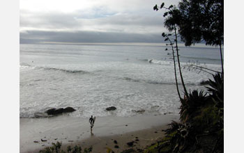
Marine Life of California's Rocky Shores (Image 1)
Coal Oil Point (also called Devereux Point) at high tide, showing just the tops of the rocky outcroppings (for comparison, see Devereux Point at low tide.)
In this area, located just up the coast from Santa Barbara, Calif., the rocky shore is more like a boulder field, with many small, turnable rocks that provide a variety of habitats. You can see here that when the water level is at high tide, the tidepool area is not even noticeable. However, at low tide, the various sized rocks attract marine animals, or "tidepoolers."
This image is part of a series about the various marine life that live in the different tide levels, or zones, of California's rocky coasts. See "Introduction to this series," below, to learn more. [Image 1 in a series. See Image 2.]
Introduction to this series
This series of images examines the various marine life that can be found in the different sea levels--or zones--of the rocky shores of the California coast. Rocky shores provide a stable substrate for plant and animal life and organisms, as opposed to sandy beaches where the substrate (sand) is constantly moving. When the tide goes out, then the influences of the air and weather (sun, rain, snow) begin to play important roles--more with the higher zones--in determining which marine life can survive.
The images in the "Marine Life of California's Rocky Shores" series were photographed by Genevieve (Genny) Anderson, a professor of biology in the Biological Sciences Department at Santa Barbara City College, as part of her ongoing research on the subject. The pictures were taken on the Santa Barbara coastline between Goleta and Carpinteria in two of the best tidepool locations in these areas: Coal Oil Point and Carpinteria State Park. Tidepools are the small bodies of water left by the ebbing tides that fill the rock basins and depressions along the shoreline.
Most areas on the Earth, including Santa Barbara, have two tidal cycles each day, created by forces in our universe--primarily the moon and sun. A high/low cycle is followed by another high/low cycle--really on a 25-hour sequence, so tides will change their time daily, getting about an hour later each day. In most areas, the two cycles are of unequal height. In a 25-hour period, there will be a high, high tide (over 5 feet above sea level). This high tide will be followed by the lowest low tide (the average of which we call zero, or sea level). Then there will be a second high tide, which averages 5 feet in Santa Barbara. This is called the low high tide. Finally there will be another low tide, averaging 2 1/2 feet above sea level in Santa Barbara. This is called the high low tide.
Although these names may seem tricky, their key heights create "zones" of horizontal stripes (bands) in the rocky intertidal that have very different environments as far as dryness goes.
Greater than 5 feet above sea level, the surface of a rocky shoreline in Southern California is covered only by the highest high tide, and thus dry three-quarters of the day. This is called the "Splash" Zone. Then, between 5 feet and 2 1/2 feet, the surface is covered alternately by both high tides so it is dry between the high tides--about half a day. This band is called the "High Tide" Zone. Between sea level and 2 1/2 feet, the rocks are only left dry at the low, low tide. This area is thus dry only a quarter of each average day and called the "Mid Tide" Zone. Then there is what we call the "Low Tide" Zone, the area below sea level that is exposed for only a few hours every few weeks at special "minus" tides (remember, 0 sea level is the average of the low, low tides). As the water goes down, most of the marine life goes out with it, but some can't move and are left on rocks. These animals must adapteto withstand not only the dryness of their area, but waves, storms, wind and rain. It is their ability to withstand dryness, and their interactions with each other (eating, being eaten, competing for space and reproducing) that determine who dominates within the rocky intertidal areas.
To learn more about Genevieve (Genny) Anderson's research on marine life along California's rocky shores, visit her website, "Tidepools (California)." Anderson, who has been a teacher of marine biology and biological oceanography at Santa Barbara City College for over 30 years, has other interesting lesson plans and lecture materials available Here.
Credit: Genny Anderson, Santa Barbara City College
Images and other media in the National Science Foundation Multimedia Gallery are available for use in print and electronic material by NSF employees, members of the media, university staff, teachers and the general public. All media in the gallery are intended for personal, educational and nonprofit/non-commercial use only.
Images credited to the National Science Foundation, a federal agency, are in the public domain. The images were created by employees of the United States Government as part of their official duties or prepared by contractors as "works for hire" for NSF. You may freely use NSF-credited images and, at your discretion, credit NSF with a "Courtesy: National Science Foundation" notation.
Additional information about general usage can be found in Conditions.
Also Available:
Download the high-resolution JPG version of the image. (62 KB)
Use your mouse to right-click (Mac users may need to Ctrl-click) the link above and choose the option that will save the file or target to your computer.