
Multimedia Gallery
Researchers use simulations to study interdependencies between people and the built environment.
Researchers create models and simulations to study interdependencies between the built environment and urban movement under everyday and crisis scenarios.
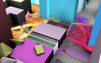
The image shows a section of downtown Salt Lake City, Utah, following a simulated earthquake. Potential safe movement paths around debris are shown as multi-color ribbons, calculated from a massively interactive agent-based model of likely behavior in the hour after the event. The height of the ribbons indicates the potential speed of movement possible; color denotes the buildings from which the trips might originate.
Credit: Paul M. Torrens, Geography and UMIACS, University of Maryland, College Park
Images credited to the National Science Foundation, a federal agency, are in the public domain. The images were created by employees of the United States Government as part of their official duties or prepared by contractors as "works for hire" for NSF. You may freely use NSF-credited images and, at your discretion, credit NSF with a "Courtesy: National Science Foundation" notation.
Additional information about general usage can be found in Conditions.
Also Available:
Download the high-resolution JPG version of the image. (1.2 MB)
Use your mouse to right-click (Mac users may need to Ctrl-click) the link above and choose the option that will save the file or target to your computer.
Related story: Designing infrastructure with resilience from disruptions and disasters