
Multimedia Gallery
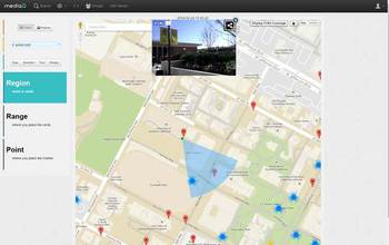
USC's spatial crowdsourcing platform, MediaQ, collects pictures and videos during disasters.
The objective of the US team for this project is to devise effective techniques for comprehensive data collection. The challenge is that, during a disaster, the availability of information is spatially biased and some areas are not well covered by available information. Towards this end, USC's spatial crowdsourcing platform, dubbed MediaQ, is being utilized to collect pictures and videos on-demand from mobile devices of people in the vicinity of the disaster areas to facilitate effective collection, orchestration and aggregation of information.
Credit: Cyrus Shahabi, USC
Images credited to the National Science Foundation, a federal agency, are in the public domain. The images were created by employees of the United States Government as part of their official duties or prepared by contractors as "works for hire" for NSF. You may freely use NSF-credited images and, at your discretion, credit NSF with a "Courtesy: National Science Foundation" notation.
Additional information about general usage can be found in Conditions.
Also Available:
Download the high-resolution JPG version of the image. (40.5 KB)
Use your mouse to right-click (Mac users may need to Ctrl-click) the link above and choose the option that will save the file or target to your computer.
Related story: New U.S.-Japan collaborations bring Big Data approaches to disaster response