
Multimedia Gallery
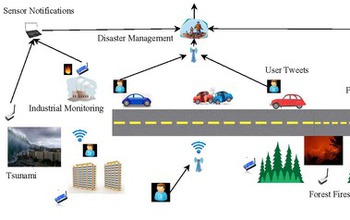
A sensor cloud connects different types of sensor networks in a large geographical area.
A sensor cloud that connects different types of sensor networks spreading in a large geographical area and is accessible by multiple users at the same time, will be used to address the critical information collection, analysis, and processing in disaster management applications. This figure depicts the proposed sensor cloud architecture integrated with a big data management framework. The sensor cloud collects multi-dimensional data from the sensors which are embedded in the environment, available in mobile devices, and generated by social media. The collected data are spatiotemporally indexed in such a fashion that they provide a scalable and robust big data indexing framework for efficient insertion, updating and analysis. The system optimizes network bandwidth and enables faster analysis of past data/events as well as dissemination of timely and correct information to people responsible for decision making.
Credit: Sanjay Madria, Missouri University of Science and Technology
Images credited to the National Science Foundation, a federal agency, are in the public domain. The images were created by employees of the United States Government as part of their official duties or prepared by contractors as "works for hire" for NSF. You may freely use NSF-credited images and, at your discretion, credit NSF with a "Courtesy: National Science Foundation" notation.
Additional information about general usage can be found in Conditions.
Also Available:
Download the high-resolution JPG version of the image. (159.1 KB)
Use your mouse to right-click (Mac users may need to Ctrl-click) the link above and choose the option that will save the file or target to your computer.
Related story: New U.S.-Japan collaborations bring Big Data approaches to disaster response