
Multimedia Gallery
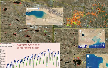
The global water monitoring system detected expansion of lakes in Tibet due to melting glaciers.
The researchers' global water monitoring system detected the expansion of lakes in Tibet due to melting glaciers. Red dots represent glacial lakes that have expanded in size since 2000. A zoomed-in view of two regions (shown in yellow) show the gain in the water extent of glacial lakes (in red). The aggregate dynamics in the surface area of all glacial lakes in Tibet for the last 15 years is shown in the time series in the bottom left.
Credit: Understanding Climate Change Expedition
Images credited to the National Science Foundation, a federal agency, are in the public domain. The images were created by employees of the United States Government as part of their official duties or prepared by contractors as "works for hire" for NSF. You may freely use NSF-credited images and, at your discretion, credit NSF with a "Courtesy: National Science Foundation" notation.
Additional information about general usage can be found in Conditions.
Also Available:
Download the high-resolution JPG version of the image. (301.7 KB)
Use your mouse to right-click (Mac users may need to Ctrl-click) the link above and choose the option that will save the file or target to your computer.
Related story: Using data to better understand climate change