
All Images
News Release 04-091
New Map Reveals Hidden Features of Ice-buried Antarctic Lake
Measurement shows that two distinct ecosystems may exist
This material is available primarily for archival purposes. Telephone numbers or other contact information may be out of date; please see current contact information at media contacts.
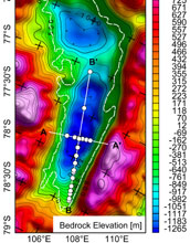
An image of the contours of the bed of Lake Vostok from data obtained by gravity measurements.
Credit: Michael Studinger / National Science Foundation
Download the high-resolution JPG version of the image. (4.4 MB)
Use your mouse to right-click (Mac users may need to Ctrl-click) the link above and choose the option that will save the file or target to your computer.

View Video
Video from the National Science Foundation's East Camp at Lake Vostok.
Credit: National Science Foundation