
All Images
News Release 07-158
Digital Eyes in the Sky Play Key Role in Battling Flames in Southern California
While staff evacuated, innovative local wireless network provided real-time images of the fires
This material is available primarily for archival purposes. Telephone numbers or other contact information may be out of date; please see current contact information at media contacts.
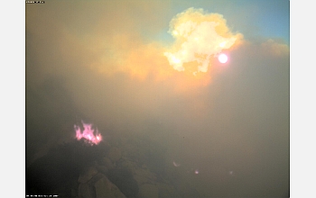
This shot from the real-time HPWREN-connected atop Lyons peak was taken and archived on 7:48am on Wednesday, Oct. 24, 2007, during the height of the Harris fire, which burned almost 100,000 acres in San Diego County last week.
Credit: HPWREN, funded by National Science Foundation.
Download the high-resolution JPG version of the image. (89 KB)
Use your mouse to right-click (Mac users may need to Ctrl-click) the link above and choose the option that will save the file or target to your computer.
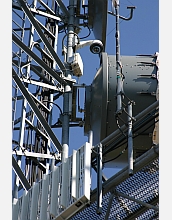
HPWREN, when new, perched on a San Diego area mountaintop.
Credit: HPWREN, Funded by the National Science Foundation
Download the high-resolution JPG version of the image. (580 KB)
Use your mouse to right-click (Mac users may need to Ctrl-click) the link above and choose the option that will save the file or target to your computer.