
All Images
News Release 12-039
Live Chat on Thursday, March 1st: Avalanche! In a No-Snow Winter, Why the Threat is High
And what atmospheric science can tell us about snow, weather and climate
This material is available primarily for archival purposes. Telephone numbers or other contact information may be out of date; please see current contact information at media contacts.

Can an avalanche be predicted? Atmospheric scientists are working to find answers.
Credit: U.S. National Park Service
Download the high-resolution JPG version of the image. (21 KB)
Use your mouse to right-click (Mac users may need to Ctrl-click) the link above and choose the option that will save the file or target to your computer.
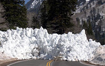
Most hazardous road in the U.S.? Utah's highway 210 is avalanche central.
Credit: Town of Alta, Utah
Download the high-resolution JPG version of the image. (18 KB)
Use your mouse to right-click (Mac users may need to Ctrl-click) the link above and choose the option that will save the file or target to your computer.
Atmospheric scientist Jim Steenburgh checks out his latest snow forecast.
Credit: Tyler Cruickshank
Download the high-resolution JPG version of the image. (269 KB)
Use your mouse to right-click (Mac users may need to Ctrl-click) the link above and choose the option that will save the file or target to your computer.
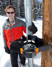
Tim Garrett, an atmospheric scientist, is using sophisticated technology to study snow.
Credit: Derek Smith
Download the high-resolution JPG version of the image. (598 KB)
Use your mouse to right-click (Mac users may need to Ctrl-click) the link above and choose the option that will save the file or target to your computer.
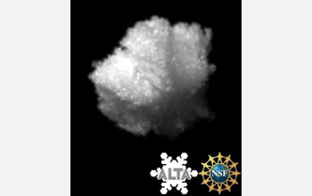
Before it melts: snowflake captured by a camera designed to record snow as it falls.
Credit: National Science Foundation/University of Utah/Alta Ski Area
Download the high-resolution JPG version of the image. (40 KB)
Use your mouse to right-click (Mac users may need to Ctrl-click) the link above and choose the option that will save the file or target to your computer.
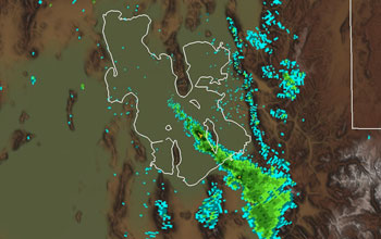
Radar image of a lake-effect snowband that extends over Alta and environs.
Credit: University of Utah
Download the high-resolution JPG version of the image. (237 KB)
Use your mouse to right-click (Mac users may need to Ctrl-click) the link above and choose the option that will save the file or target to your computer.