
All Images
News Release 13-145
Global sea level rise temporarily dampened by 2010-11 Australia floods
Finding shows complex nature of Earth's climate interactions
This material is available primarily for archival purposes. Telephone numbers or other contact information may be out of date; please see current contact information at media contacts.
The city of Rockhampton, Queensland, Australia, shown in a satellite photo, was completely inundated by the floods.
Credit: NASA
Download the high-resolution JPG version of the image. (160 KB)
Use your mouse to right-click (Mac users may need to Ctrl-click) the link above and choose the option that will save the file or target to your computer.

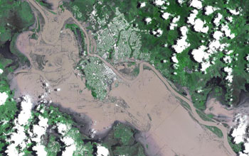
Australia's Fitzroy River in January 2011; its flooding isolated the city of Rockhampton, as shown in a satellite photo.
Credit: NASA
Download the high-resolution JPG version of the image. (3.2 MB)
Use your mouse to right-click (Mac users may need to Ctrl-click) the link above and choose the option that will save the file or target to your computer.
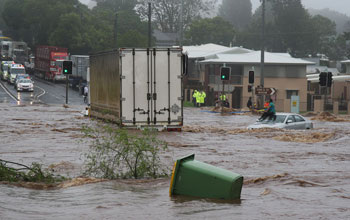
A woman in Australia awaits rescue on a car roof.
Credit: Government of Australia
Download the high-resolution JPG version of the image. (149 KB)
Use your mouse to right-click (Mac users may need to Ctrl-click) the link above and choose the option that will save the file or target to your computer.
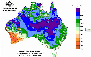
Rainfall in Australia in 2010 reached levels far above normal.
Credit: Government of Australia
Download the high-resolution GIF version of the image. (80 KB)
Use your mouse to right-click (Mac users may need to Ctrl-click) the link above and choose the option that will save the file or target to your computer.
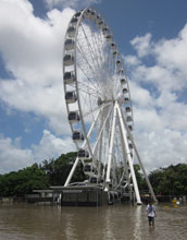
The entrance to the high ferris wheel in Brisbane is submerged under water.
Credit: Government of Australia
Download the high-resolution JPG version of the image. (1.7 MB)
Use your mouse to right-click (Mac users may need to Ctrl-click) the link above and choose the option that will save the file or target to your computer.
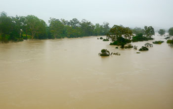
The flooded Burnett River at Gayndah, Australia, 220 miles northwest of Brisbane.
Credit: Government of Australia
Download the high-resolution JPG version of the image. (7.4 MB)
Use your mouse to right-click (Mac users may need to Ctrl-click) the link above and choose the option that will save the file or target to your computer.