
News Release 05-132
Rainbands Offer Better Forecasts of Hurricane Intensity
Research project to improve forecasting
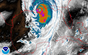
Scientists from the RAINEX project flew into the edge of Hurricane Katrina to study its rainbands.
August 8, 2005
This material is available primarily for archival purposes. Telephone numbers or other contact information may be out of date; please see current contact information at media contacts.
Scientists will soon begin one of the largest research projects ever undertaken to better understand dramatic, rapid changes in hurricane intensity. These changes have baffled forecasters for decades.
Atmospheric scientists from the University of Miami Rosenstiel School of Marine & Atmospheric Science (RSMAS), the University of Washington and the National Center for Atmospheric Research (NCAR) in Boulder, Colo., will participate in the new project, called the Hurricane Rainband and Intensity Change Experiment, or RAINEX.
RAINEX will study how the outer rain bands and inner eye of a hurricane interact to influence a storm's intensity.
"While great progress has been made in forecasting hurricane tracks, we need to improve forecasting of hurricane intensity," said Steve Nelson, director of the National Science Foundation's (NSF) physical and dynamic meteorology program, which funds RAINEX. "Many factors affect the intensity of hurricanes," Nelson said. RAINEX scientists will investigate one of those factors: the interactions between hurricane rainbands and the eyewall. "From RAINEX, we will better understand the impact of rainbands on a hurricane's maximum winds," he said.
While researchers have studied the eye and outer rainbands of hurricanes extensively, "few, if any, experiments have ever examined these two components together and how their interaction might affect a storm's strength," said Shuyi Chen, a meteorologist and physical oceanographer at RSMAS and a RAINEX principal investigator. "The outer bands of a hurricane often have strong winds and lots of rain, and that can actually affect the overall intensity of a hurricane," she said.
RAINEX will study this interaction using data recorded from hurricane research flights. Starting on Aug. 15 and continuing through the remainder of this year's Atlantic hurricane season, two NOAA P3 aircraft, along with a U.S. Navy P3 aircraft, all equipped with Doppler radar, will fly simultaneously into hurricanes well before they threaten landfall.
The University of Washington and NCAR, will conduct research using airborne Doppler radar analysis. RSMAS will construct a state-of-the-art hurricane model using the data collected from the research flights.
"These flights can be turbulent, especially when we're penetrating a hurricane's rainbands," said NCAR scientist Wen-Chau Lee. "I think that's the wild card, the challenge of the experiment: to capture internal rainband structure and its interactions with the eye wall in those conditions."
"We hope to find an explanation for why a hurricane changes in intensity, from the relationship between the inner and outer parts of the storm," said Robert Houze, an atmospheric scientist at the University of Washington and a RAINEX co-principal investigator. "These storms can jump up in intensity, or drop a full category in a day, a big challenge."
Flying in the hurricane's outer bands and into the eye wall, scientists aboard the aircraft will use sophisticated Doppler radar and GPS dropsondes to record wind speed and direction, temperature, humidity, atmospheric pressure and other critical data.
Much of what scientists currently know about the interaction between the outer rainbands and the eye wall of a hurricane comes from the state-of-the-art numerical models developed for hurricane research and prediction, which can provide very detailed information but may not be completely accurate.
Researchers need solid data to validate these models, they say. "We need to know whether or not our models are accurate, and the data we collect from RAINEX will give us the information we need," Chen said.
Once the data are collected, the researchers will all analyze and share this information with hurricane operational centers and national environmental prediction centers throughout the country, and the world.
-NSF-
-
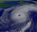
Hurricane Alex in Aug. 2004
Credit and Larger Version -
Debris was deposited from the tidal surge of hurricane Ivan in Pensacola, Fla., Sept. 18, 2004.
Credit and Larger Version

Media Contacts
Cheryl Dybas, NSF, (703) 292-7734, email: cdybas@nsf.gov
Ivy Kupec, RSMAS, (305) 421-4704, email: ikupec@rsmas.miami.edu
Vince Stricherz, UW, (206) 543-2580, email: vinces@u.washington.edu
Anatta , UCAR/NCAR, (303) 497-8604, email: anatta@ucar.edu
Related Websites
RAINEX: http://www.joss.ucar.edu/rainex
The U.S. National Science Foundation propels the nation forward by advancing fundamental research in all fields of science and engineering. NSF supports research and people by providing facilities, instruments and funding to support their ingenuity and sustain the U.S. as a global leader in research and innovation. With a fiscal year 2023 budget of $9.5 billion, NSF funds reach all 50 states through grants to nearly 2,000 colleges, universities and institutions. Each year, NSF receives more than 40,000 competitive proposals and makes about 11,000 new awards. Those awards include support for cooperative research with industry, Arctic and Antarctic research and operations, and U.S. participation in international scientific efforts.
Connect with us online
NSF website: nsf.gov
NSF News: nsf.gov/news
For News Media: nsf.gov/news/newsroom
Statistics: nsf.gov/statistics/
Awards database: nsf.gov/awardsearch/
Follow us on social
Twitter: twitter.com/NSF
Facebook: facebook.com/US.NSF
Instagram: instagram.com/nsfgov