
News Release 10-176
NSF Awards Grant for Continuously Operating Caribbean GPS Natural Hazards Observational Network
COCONet will transform understanding of earthquakes, hurricanes in vulnerable region
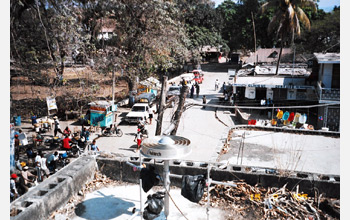
In a pre-earthquake photo, a GPS receiver and antenna sit atop a roof in Port-au-Prince, Haiti.
October 5, 2010
This material is available primarily for archival purposes. Telephone numbers or other contact information may be out of date; please see current contact information at media contacts.
How can we better understand and assess seismic and other natural hazards in the Caribbean and Central America?
What are the slip rates along active faults that bound the Caribbean tectonic plate? How is stress released at these plate boundaries?
How sensitive is tropospheric water vapor content to changes in sea surface temperatures? How does the distribution of water vapor across the Caribbean region influence the genesis, intensification and direction of tropical storms and hurricanes?
To find answers, the National Science Foundation (NSF) has awarded a grant for the development of a tectonic plate-scale integrated geodetic and atmospheric/regional climate observational system in the pan-Caribbean region.
COCONet, the Continuously Operating Caribbean GPS Observational Network, will add 50 continuously operating Global Positioning System (cGPS) stations to those in place in Caribbean and Caribbean-border nations.
The COCONet grant is being awarded to UNAVCO, Inc., a national geodetic support facility in Boulder, Colo., funded by NSF's Division of Earth Sciences, and to the University Corporation for Atmospheric Research (UCAR), a consortium supported by NSF's Division of Atmospheric and Geospace Sciences and which includes the National Center for Atmospheric Research (NCAR) in Boulder, Colo.
"COCONet has the potential to transform our understanding of seismic and hurricane hazards in the extremely vulnerable Caribbean region," says Robert Detrick, director of NSF's Division of Earth Sciences, "and to support basic research into plate tectonic processes and regional climate change."
"This is a very exciting opportunity for interdisciplinary science," says Meghan Miller, President of UNAVCO, Inc., "and will provide a regional framework for new discoveries about the fundamental processes that control tectonic and atmospheric unrest."
The new cGPS stations will, in some cases, be co-located with existing tide gauges, supporting studies of sea-level change in response to global warming.
They will be linked with surface meteorological instruments to expand geodetic and atmospheric observational infrastructure in a region with complex tectonics and with substantial earthquake, tsunami, volcanic, tropical storm and hurricane, flooding and landslide hazards.
"COCONet will complement current seismic, tsunami, hurricane and landslide monitoring systems in the Caribbean region, and become an international platform for multi-hazard research and education," says Guoquan Wang of the Puerto Rico Seismic Network and a geologist at the University of Puerto Rico.
COCONet data will be freely available through UNAVCO, and will enable observations with immediate relevance for understanding, mitigating and predicting regional geohazards.
The data will flow via the EarthScope Plate Boundary Observatory (PBO). From there, the data will be processed into geodetic products.
In addition, scientists will estimate tropospheric precipitable water vapor (PV) every 30 minutes from observations of GPS radio frequency signals.
These observations will be used to improve numerical weather models and may eventually be incorporated into operational forecasting systems.
The project will allow Caribbean researchers to use COCONet data for both scientific and socioeconomic purposes.
Real-time data from COCONet will be made available to the international scientific community in a region of the globe with few existing real-time data sources.
"By establishing a single unified GPS network spanning the entire region, and by providing freely available, high-quality geodetic and meteorological data to researchers in both the U.S. and the Caribbean region, COCONet will be a major step in advancing Earth science research in this area," says Russ Kelz, program director in NSF's Earth Sciences Division.
With COCONet, the risk of future Caribbean earthquakes, hurricanes and other natural hazards will be far better understood.
-NSF-
-
COCONet stations will monitor natural hazards throughout the Caribbean region.
Credit and Larger Version -
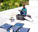
Louis Obenson of Haiti's Civil Protection Agency installs GPS equipment in Port-au-Prince.
Credit and Larger Version -
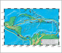
The seismotectonic context of Earth's Caribbean tectonic plate is shown in this map.
Credit and Larger Version -
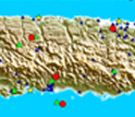
The current GPS-seismic-tide gauge monitoring network in Puerto Rico and the Virgin Islands.
Credit and Larger Version

Media Contacts
Cheryl Dybas, NSF, (703) 292-7734, email: cdybas@nsf.gov
The U.S. National Science Foundation propels the nation forward by advancing fundamental research in all fields of science and engineering. NSF supports research and people by providing facilities, instruments and funding to support their ingenuity and sustain the U.S. as a global leader in research and innovation. With a fiscal year 2023 budget of $9.5 billion, NSF funds reach all 50 states through grants to nearly 2,000 colleges, universities and institutions. Each year, NSF receives more than 40,000 competitive proposals and makes about 11,000 new awards. Those awards include support for cooperative research with industry, Arctic and Antarctic research and operations, and U.S. participation in international scientific efforts.
Connect with us online
NSF website: nsf.gov
NSF News: nsf.gov/news
For News Media: nsf.gov/news/newsroom
Statistics: nsf.gov/statistics/
Awards database: nsf.gov/awardsearch/
Follow us on social
Twitter: twitter.com/NSF
Facebook: facebook.com/US.NSF
Instagram: instagram.com/nsfgov