
News Release 05-165
Seeing Into the Eye of Hurricane Rita
Weather model advances hurricane intensity prediction
NCAR models the development of southeastern hurricanes once or twice daily.
September 22, 2005
This material is available primarily for archival purposes. Telephone numbers or other contact information may be out of date; please see current contact information at media contacts.
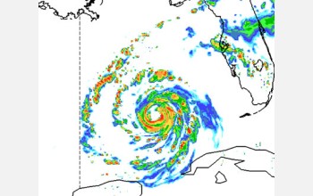
An advanced research weather model run by the National Center for Atmospheric Research (NCAR) in Boulder, Colo., is following Hurricane Rita to give scientists a taste of how well forecast models of the future may predict hurricane track, intensity, and important rain and wind features.
See the model's daily storm projection at http://www.ucar.edu.
With its high-resolution grid of data points just about 2.5 miles (4 kilometers) apart, the model can project the location of fine-scale rain bands and eyewall structures 48 hours into the future.
It's these features of the storm that determine where the greatest damage from both rain and wind might occur, says NCAR weather expert Chris Davis. Current operational forecast models use a coarser resolution and must approximate the cloud processes affecting intensity and precipitation.
Known as ARW, the computer model is NCAR's research version of the Weather Research and Forecasting model (WRF), a joint effort by university and government scientists.
"ARW intensity predictions are very encouraging," says Davis. "Five years ago, accurate intensity predictions weren't even possible."
Adds Cliff Jacobs of the National Science Foundation's atmospheric sciences division, "The ability to make these forecasts, which are becoming increasingly accurate, has far broader impacts beyond the study of meteorology. NSF funds NCAR.
The model captured in detail the collapse of Hurricane Katrina's eyewall at landfall and the shift of precipitation to the north side of the storm. Had the eyewall's structure remained coherent, the winds would have been far more devastating. The eyewall always weakens at landfall, says Davis.
Teams supporting the U.S. Department of Energy and U.S. Department of Homeland Security are using real-time ARW data in their damage models. Researchers are testing how computer simulations of a particular hurricane's most-destructive features can lead to better warnings of floods, power outages, and road blockage. This year's test cases have included Hurricanes Katrina, Ophelia, and Rita.
Meanwhile, a hurricane experiment in Fla. is investigating the interactions between Hurricane Rita's rain bands and its eyewall. NCAR's Wen-Chau Lee and colleagues are flying through the storm aboard a Naval Research Laboratory P-3 aircraft to gather radar data from inside the bands.
The observations from the Hurricane Rainband and Intensity Change Experiment (RAINEX), also funded by NSF, will help scientists better understand the impact of the rainbands on the storm's maximum winds.
-NSF-
-
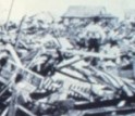
Damage caused by the Galveston hurricane of 1900 is the worst in U.S. history.
Credit and Larger Version -
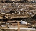
This part of Slidell, La., was flattened by Hurricane Katrina.
Credit and Larger Version
Media Contacts
Cheryl L. Dybas, NSF, (703) 292-7734, email: cdybas@nsf.gov
Anatta , UCAR/NCAR, (303) 497-8604, email: anatta@ucar.edu
The U.S. National Science Foundation propels the nation forward by advancing fundamental research in all fields of science and engineering. NSF supports research and people by providing facilities, instruments and funding to support their ingenuity and sustain the U.S. as a global leader in research and innovation. With a fiscal year 2023 budget of $9.5 billion, NSF funds reach all 50 states through grants to nearly 2,000 colleges, universities and institutions. Each year, NSF receives more than 40,000 competitive proposals and makes about 11,000 new awards. Those awards include support for cooperative research with industry, Arctic and Antarctic research and operations, and U.S. participation in international scientific efforts.
Connect with us online
NSF website: nsf.gov
NSF News: nsf.gov/news
For News Media: nsf.gov/news/newsroom
Statistics: nsf.gov/statistics/
Awards database: nsf.gov/awardsearch/
Follow us on social
Twitter: twitter.com/NSF
Facebook: facebook.com/US.NSF
Instagram: instagram.com/nsfgov