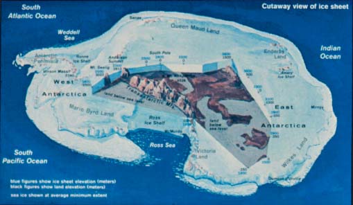
Antarctica is composed of two major, geologically distinct parts bridged by a vast ice sheet (Exhibit 2). East Antarctica, the larger of the two, is roughly the size of the U.S. (Exhibit 3) and is composed of continental crust covered by an ice sheet that averages 1.6 miles thick. Rock exposures are limited to isolated coastal regions and to alpine elevations in the 2,000-mile long Transantarctic Mountains. West Antarctica, the smaller portion, is a mosaic of small blocks of continental crust covered by the West Antarctic Ice Sheet and an Andean-like mountain chain forming the Antarctic Peninsula. Most of the West Antarctic Ice Sheet is grounded below sea level, in places over 1.5 miles below sea level.
Exhibit 2
Antarctica, with cutaway showing ice sheet and bedrock.
Exhibit 3
Antarctica's area of 5.4 million square miles makes it 1.5 times the size of the conterminous U. S.
The continent itself is depressed more than half-a-mile to near sea level under the tremendous load of the ice sheet, with some regions well below sea level. The highest mountains rise to elevations of over 14,000 ft. about the height of the U.S. Rocky Mountains.
The present Antarctic ice sheet accounts for 90 percent of Earth's total ice volume and 70 percent of its fresh water. It houses enough water to raise global sea level by 200 ft. if completely melted. The ice sheet at the Pole, nearly two miles thick, is constantly shifting, carrying the facility at the Pole along with it at the rate of about 30 ft. a year. Nearly 90 percent of the ice flowing across West Antarctica converges into ice streams that are the most dynamic, and perhaps unstable, components of the ice sheet. Recent glaciological observations have yielded evidence that some of these West Antarctic ice streams may be responding to climatic and sea level changes of the recent past, changes that could lead to more rapid retreat and global sea-level rise in the future. A few active volcanoes may also affect the ice sheet's behavior.
The Antarctic climate offers a formidable challenge to those who venture there in quest of scientific knowledge. It is the coldest, driest, highest (on average) and windiest continent on Earth. Absolute humidity is lower than on the Sahara. Annual snowfall in much of the interior is less than two inches. Winds that flow down the surface of the ice sheet toward the coast (katabatic winds) commonly reach speeds of 80 miles per hour, and maximum measured wind speeds have exceeded 180 miles per hour. Changes in the weather are dramatic: winds shift from calm to full-gale in a brief period of time. A drop of 65°F was once recorded in 12 minutes. Earth's lowest surface temperature (-126.9°F) was recorded at Russia's Vostok Station in the interior of Antarctica. Coastal locations in summer occasionally rise above the freezing point (Exhibit 4).
Exhibit 4
Antarctic temperatures. Spring and fall, in polar terms, are more aptly morning and evening twilight. Particularly in the continental interior, the temperature drops quickly when the Sun sets in March, and rises with the Sun's rise in September. This graph shows temperatures in 1989 at three locations the clean air facility at South Pole Station (90°S), the helicopter fuel depot at Marble Point (78°S, across the sound from McMurdo), and on Scott Island (66°S) in the southern ocean. The data were collected by unattended automatic weather stations and transmitted by satellite every two minutes to the University of Wisconsin in Madison, from where they were sent by request over the Internet to a winterer at McMurdo Station, who produced this graph as part of an evaluation of latitudinal temperature variations. The graph shows that, at South Pole in 1989, both summer and winter temperatures happened to come close to the station's historic recorded extremes of 7°F and -117°F.
At the South Pole, the nights are six months long, extending from sunset on March 21 to sunrise on September 21. A lake (Lake Vostok) buried 11,000 ft. under the ice is the size of North America's Lake Huron.
Offshore cyclones occur with little warning. Winds typically reach hurricane strength within an hour and persist for several days. A concentration of storm formation and/or intensification occurs at approximately 50°S latitude and is associated with some of the most violent seas in the world ("the roaring forties"). The stretch of ocean between Antarctica and the tip of South America is considered the most hostile in the world and has claimed numerous ships over the centuries.
The stable upper atmospheric (stratospheric) air mass over the continent has been seriously altered by synthetic chemicals that arrived via natural atmospheric circulation from the world's industrial areas, resulting in the creation of the well-known Antarctic ozone hole. Ice core records provide evidence that atmospheric greenhouse gases such as carbon dioxide and methane have increased markedly during the past 200 years and are presently more prevalent than at any time in the past 160,000 years. These records also show that low temperatures of the ice age occurred when greenhouse-gas concentrations were low.
Meteorological observations have been recorded only in recent decades, and then only in scattered localities, so long-term temperature trends remain uncertain. The longest instrumental temperature records come from the relatively warm Antarctic Peninsula region, referred to by the "Frozen Chosen" as the "Banana Belt" of Antarctica. The glacial systems that occur in the Peninsular region are the most delicate in Antarctica and the most vulnerable to climatic warming. In historical time the fronts of the Larsen and George VI ice shelves, the two largest ice shelves in the region, have retreated at rates of nearly one-half mile per year. Another smaller ice shelf, the Wordie Ice Shelf, has completely vanished during the past several decades. Whether these changes are due to induced global warming or to natural (perhaps regional) climatic cycles remains uncertain.
Millions of square miles of sea ice surround Antarctica; the extent annually experiences a five-fold increase and decrease, with the winter maximum more than doubling the entire Antarctic region's area of ice coverage. Icebergs larger than the State of Connecticut have been observed. The temperature gradient associated with Antarctica's sea-ice zone is one of the strongest on Earth, and the seasonal variability in the extent of sea ice is an important regulator of the climate of the Southern Hemisphere. This is primarily because of the significant difference between sea ice and water in reflecting the sun's energy (albedo) and because the sea ice serves as a barrier to energy exchange between atmosphere and ocean. The extent of sea ice around Antarctica also regulates (and stimulates) primary productivity of microorganisms in surface waters, and the sea ice zone is one of the most dynamic biological systems on Earth. Global warming could cause a significant reduction in the extent of the sea ice; the potential climatic and biological impacts of a change remain problematic.
Ocean circulation and water mass production in the Antarctic region are unique owing to the strong influence of sea ice and ice shelves on temperature and salinity and to a virtual absence of geographic obstacles to circulation around the continent. A key ingredient of the global ocean is the very cold, saline water that forms in regions of the Antarctic's continental shelf. This water is supercooled by exposure to ice shelves (floating glacial ice still attached to the land), and its salinity is increased by salt that is expelled from freezing sea water during annual sea ice production. This water flows off the Antarctic continental shelf and into the global ocean as Antarctic Bottom Water, the coldest and saltiest water mass in the deep ocean and a primary driver in global ocean circulation (Exhibit 5). Elsewhere around Antarctica, relatively warm water masses flow onto the continental shelf and melt the undersides of ice shelves. This feedback between water masses and ice shelves is still not well understood.
Exhibit 5
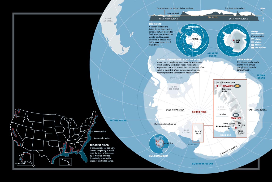
How Antarctic ice affects world climate. Think of the Antarctic ice sheet as Earth's refrigeration unit: It exerts a major two-way control over today's global environment. First, the ice sheet (along with sea ice that surrounds it in the southern ocean) reflects back into space about 80 to 85 percent of the Sun's energy that hits it. So icy Antarctica, which records the lowest temperatures on Earth, helps to reduce the world's overall heat budget. Second, the near-freezing meltwater that runs off the ice sheet, along with the water from melting icebergs, falls to the ocean floor and moves northward. This surge affects deep-sea circulation, which in turn influences climate. A major meltdown would raise sea level worldwide and could modify weather patterns. Drawing source: February 1997 © Popular Science (Infographic © 1997 by John Grimwade).
Life forms on the Antarctic continent are sparse because of the severe climate. Nevertheless, biologists have found bacteria and yeast growing just 183 miles from the South Pole. A lichen was found in a sunny canyon 210 miles from the Pole, and a blue-green alga was observed in a frozen pond 224 miles from the Pole. Microbes related to lichens colonize in green and brown layers just beneath the surface of rocks facing the Sun. Mosses and liverworts grow in some ice-free areas along the coast. Two species of flowering plants a grass and an herb grow along the Antarctic Peninsula.
The native land animals are limited to arthropods (insects and the like), of which 76 species have been discovered. Nearly all of these species are found only in Antarctica. These springtails, midges and mites generally live along the coast among plant colonies. The southernmost known animal, a mite, has been found 315 miles from the South Pole.
Sea life, in contrast to the land, is bounteous. The immense numbers of birds and seals that live in Antarctica are, properly speaking, sea animals. They spend most of their time in or over the water, where they get their food. These animals come ashore only to breed.
About 45 species of birds live south of the Antarctic Convergence (Exhibit 6). Of the seven penguin species, two the emperor and the Adélie are distributed widely around the entire coastline. Gentoo and chinstrap penguins occupy Antarctic Peninsula coasts. The population of birds in the Antarctic is estimated to be 350 million, of which about half are penguins. The total weight of birds is estimated in excess of 400,000 tons greater than the combined weight of Antarctic seals and whales.
Exhibit 6
A year in the life of an emperor penguin
At a height of 4 feet, emperors are the largest of the world's 17 penguin species. They can weigh 90 pounds. Only 42 colonies, all in the Antarctic, are known, and the total emperor population is an estimated 200,000 breeding pairs a small fraction of Antarctica's 180 million penguins.
January-March. It's late summer, and the birds are at sea fattening up on a diet of 95 percent fish, 3 percent squid, and 2 percent krill.
March-April. The penguins walk "inland" across the frozen sea, taking a week or more to go 60 to 100 miles to the traditional colony site.
May-June. It takes 5 to 8 weeks to walk across the ice, select a mate, and, for the female, lay the single 1-pound egg. She incubates it for several hours, keeping it warm in a brooding pouch that is a fold of skin just over her feet, then transfers it to her mate who proceeds to balance the egg on top of his feet for weeks to keep it from freezing. Twelve hours later she goes back to the open sea, having lost 20 to 25 percent of her weight since leaving it, her only source of food.
Late May-August. It's winter. The male incubates the egg in the dark of winter at temperatures as low as minus 70°F. He loses about 7 ounces of fat a day during the 64-day incubation. Chicks hatch in July and August. Despite not having eaten for 4 months, the male is able to feed the chick from his own gut. In a feat of timing and navigation, the female returns within a few days of the hatching.
August-September. The male goes to sea, crossing the sea ice at its winter maximum, perhaps hundreds of miles. There, he replenishes his fat, while the female feeds the chick for three to four weeks. After a month the male returns and takes over chick duty.
October-November. The chick remains on the feet of the adults nearly 6 weeks. Then the parents leave the chicks unguarded. Chicks form crèches, huddling together to stay warm. During this time the parents go back and forth between the sea and the colony.
August-late December. The chick fledges about five months after hatching. During this time it is fed on average every 16 days, receiving 30 percent of its body weight at each meal. Satellite tracking of some adults has shown that their feeding journeys can take them 900 miles. Emperors are the world's deepest diving birds, reaching depths of 2,070 feet and staying under water as long as 18 minutes.
December-January. The adults desert the chicks when they are about five months old. The chicks weigh 22-23 pounds, about 45 percent of the adult's summer weight,. The ice now carries them to sea, and they will not return to breed for five years. Meanwhile, the adults fatten up at sea and return to the ice to molt, a process that takes three to four weeks.
February-March. The breeding adults now have just three to four weeks to fatten before starting their long trek across the sea ice begin again their remarkable breeding program.
text after Zegrahm News, © 1997; photo © Galen Rowell, Mountain Light Photography, 1995.
Four species of seals breed almost exclusively in the Antarctic the Weddell, crabeater, leopard, and Ross. Other species include the fur seal and the huge elephant seal. Most populous is the crabeater, estimated at 50 million to 75 million. Leopard and Weddell seals number 250,000 to 500,000 each.
Fishes peculiar to the Antarctic include the Antarctic cod and the icefish. These and other fishes have developed proteins in their blood that enable them to live in sea water as cold as 28°F that is, below the freezing temperature of fresh water. There is abundant and varied bottom life (starfish, urchins, shellfish) in most coastal waters.
Aside from phytoplankton (marine plants), a singularly important member of the Antarctic marine food chain is krill. This crustacean looks like a small shrimp and exists in huge numbers; vast swarms stretching several miles in length have been observed from ships, and some biologists believe the krill population may exceed 5 billion tons. Krill eat phytoplankton and small marine animals and in turn are eaten in great numbers by squid, birds, seals, and whales. There is evidence that depletion of the ozone layer affects phytoplankton productivity, and may therefore affect krill and the entire southern ocean food chain.
Overall, the Antarctic environment is compelling yet formidable (Exhibit 7) and it provides a unique surrounding in which to conduct research some of which has great relevance for life throughout the globe.
Exhibit 7
Antarctic Meltdown
Nine tenths of the world's ice is piled up in Antarctica. If it were to melt, sea level would rise some 200 feet, dramatically altering the shape of the U. S., among other countries. Scientific research has not established either the history of the ice sheet's former fluctuations or its future. The dynamicists infer an ice sheet that may have receded as recently as three million years ago, but the stablists think it has been generally unchanged for the last 10 to 15 million years. This "infographic" by John Grimwade is from the cover story entitled "Antarctic Meltdown," by Beth Livermore, in the February 1997 issue of Popular Science.
The Antarctic is dramatically different from the Arctic, as Exhibit 8 shows.
Exhibit 8
South Pole/North Pole.
Both of the Earth's polar regions are cold, and they share other characteristics
that distinguish them from the planet's temperate and tropical regions.
Yet, the two regions also are dramatically different from each other, as
this list shows. The map depicts the world 21,000 years ago, when the Ice
Age had extended the polar ice sheets, particularly in the north, far beyond
their present boundaries. Map furnished by Woods Hole Oceanographic Institution.
--Natural Features--
Antarctic: Continent surrounded by ocean, winds, and circumpolar ocean
currents, uninterrupted by land masses.
Arctic: Ocean surrounded by continents.
Antarctic: Icebergs derived from glaciers and shelf ice year-round
and may measure in excess of 25 cubic miles.
Arctic: Icebergs derived from glaciers, seasonal, measured in cubic yards.
Antarctic: Sea ice annual, outward growth more than doubles continent
size, annual thickness to 8 ft.
Arctic: Sea ice multi-year, circulates in polar gyre, annual thickness to
5 ft.
Antarctic: 97.6 percent of land ice covered in almost unbroken South
Polar ice sheet.
Arctic: Land ice in limited areas; largest Greenland ice sheet.
Antarctic: Elevation at South Pole 9,300 ft. above sea level; bedrock
only 100 ft. above sea level.
Arctic: Elevation at North Pole 3 ft. of sea ice; bedrock 1,400 ft. below
sea level.
Antarctic: South Pole mean annual temperature = -58°F; permanent
meteorological and astrophysical research station.
Arctic: North Pole mean annual temperature = 0°F; no research station.
Antarctic: Beaches rare; narrow deep continental shelf backed by vertical
ice cliffs.
Arctic: Beaches and shallow extensive continental shelf.
Antarctic: Frozen ground mostly limited to ice-free areas.
Arctic: Frozen ground extensive, over 1,500 ft.
-- Plants and Animals --
Antarctic: No tundra, no tree line. Subantarctic zone marked by Antarctic
Convergence.
Arctic: Tundra well developed, extensive, marked by a tree shrubline.
Antarctic: Crustaceous lichens at 82° lat; 2 species of flowering
plants at 66°70° S lat; vegetation primarily lichens and mosses.
Arctic: 90 species of flowering plants at 82° N lat, 450 species at
66°77°N lat.
Antarctic: Free-living arthropods include insects (2), mites (150),
Collembolla (6).
Arctic: Free living arthropods include Arachnids, crustaceans, insects,
and myriapods numerous and common.
Antarctic: No terrestrial mammals.
Arctic: Terrestrial mammals include musk ox, reindeer, caribou, fox, hare,
wolf, lemming, bears, etc.
Antarctic: Marine mammals limited to whales and porpoises (14) and
seals (4).
Arctic: Marine mammals include whales and porpoises (18), seals (7), amphibious
mammals (1).
Antarctic: Bird species (19) 70°80° S lat.
Arctic: Bird species (107) at 75°80° N lat.
-- Humanity --
Antarctic: No record of primitive humans; no native groups.
Arctic: Native peoples with long, rich cultural record; ethnic groups circumarctic.
Antarctic: Population south of 60° S sparse, scattered at scientific
stations. No exploitation of terrestrial resources.
Arctic: Human population 60° N, in excess of 2 million, modern settlements,
widespread exploitation and technological development.
Antarctic: Crossing of Antarctic Circle by James Cook, January 17,
1773.
Arctic: Crossing of Arctic Circle prehistoric.