 |
|||||||
3.0 Key Areas for Development of Existing Facilities
|
 |
|
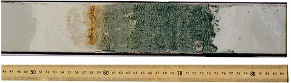
ODP Cores. Sediment and rock cores recovered by drilling the seafloor provide access to a vast repository of geological and environmental information on Earth's history. The core shown above, collected 300 miles off the northeast Florida coast, reveals an amazingly detailed record of a meteorite impact event in the Caribbean 65 million years ago. This event is believed to have caused mass extinction, perhaps as much as 70 percent of all species, including the dinosaurs. The dark layer contains the debris from the impact. The rust colored layer represents the debris from the vaporized meteorite. The graded gray core material overlying the rust layer shows the gradual repopulating of the ocean with microorganisms. The approximately 40 cm of core material was collected at a water depth of about 2600 meters, 110 meters below the seafloor. Other cores contain detailed records of past environmental changes, helping to better understand the critical processes and mechanisms controlling the climate system, and correlating land and marine climate records. Results from coring the ocean crust have also been striking. For example, in the early days of scientific drilling, beginning in 1968, cores proved the hypotheses of seafloor spreading through the relationship of crustal age and magnetic reversals. This led to our present concept of plate tectonics. The ODP provides the only capability for scientific sampling of anything but the shallowest layers of ocean sediments and crust. |
- The Global Seismographic Network (GSN)20 is a network of over 108 broadband, digital seismic stations distributed globally to monitor earthquakes, underground nuclear explosions, volcanic activity, and to research deep Earth structure. GSN station operation and maintenance is managed by IRIS, collaborating with the USGS, the University of California at San Diego, other U.S. university groups, and cooperating international seismic networks partners, including GEOSCOPE (France), MEDNET (Italy), POSEIDON (Japan), and GEOFON (Germany). Seismic data acquired through the GSN is an indispensable resource for many seismological research areas: tomographic imaging of core, mantle, and lithosphere structure, rapid and accurate location of earthquakes and other seismic sources, and better understanding of the driving forces moving lithospheric plates and crustal deformation patterns leading to earthquakes.
-
Anticipated improvements of the GSN to ensure continuing exciting scientific
discoveries during 1999-2003 and beyond include: (1) up to 35 new station
installations to complete the global (land-based) coverage, (2) operating
a key Pacific Ocean GSN seafloor station, Hawaii-2 Observatory (H2O),
with an ocean bottom broadband seismometer midway between Hawaii and
California on a donated AT&T wire cable, (3) conversion of selected
stations to `geophysical observatories,' with addition of GPS receivers,
magnetometers, gravimeters, and microbarographs to form the nucleus
of a multi-purpose geophysical network, and (4) continued improvements
of telecommunication capabilities for rapid data acquisition and distribution.
Seismic Instrumentation3, 20, 28, 29, 30, 31 A large pool of portable seismometers, available worldwide for field deployment, is provided by the IRIS-PASSCAL Program (Program of Array Seismic Studies of the Continental Lithosphere). The PASSCAL pool consists of over 400 seismic recording systems, with a total capacity of more than 1500 channels, and includes 200 broadband sensors, as well as intermediate period instruments. The PASSCAL instruments are serviced and supported by an instrument center located at the New Mexico Institute of Mining and Technology. Since its inception, the PASSCAL Facility has supported over 180 field experiments. The capabilities of the PASSCAL pool are complementary to the GSN, allowing for higher-resolution imaging with closer spacing of stations and special array geometries. Possible improvements and activities anticipated during 1999-2003 include: (1) significantly increasing the existing instrument pool capacity in order to reduce the current wait of 18-30 months to instrument field projects, (2) expanding the use of telemetry and extending the capabilities of broadband arrays, and (3) acquiring small, lightweight, inexpensive instruments, activated to record by radio command and intended for use in active source experiments for high-resolution crustal imaging experiments needing many instruments at close spacing.
Whole Earth Dynamics. Data from the IRIS GSN can map the variation of the velocity of seismic waves in the Earth (tomography). These variations depend on both temperature and the crystallographic orientation of the material the seismic wave is passing through (anisotropy). Until recently, the effect of temperature, which produces isotropic variations in seismic velocity, was believed to be much greater than the effect of anisotropy. For example, velocity variations in the upper mantle beneath the Pacific Ocean were thought to result from the cooling of oceanic lithosphere as it moves away from the East Pacific Rise spreading center. A new global three-dimensional tomographic model of seismic velocity shows that the uppermost mantle beneath the Pacific Ocean is considerably more complicated than this simple thermal model. The figure shows that the anisotropic variations in velocity (top panel) are at least as large as the isotropic variations (bottom panel) due to temperature. The bottom panel also correlates the isotropic variations with the age of the seafloor, as expected from a simple thermal cooling model. The anisotropic variations, however, do not appear to be correlated with the age of the seafloor. Because seismic anisotropy is an indicator of strain in Earth materials, these results can be used to put constraints on both buoyancy forces (thermal effects) and flow patterns in the upper mantle (anisotropy). |

- Ocean-Bottom Seismic (OBS) Instrumentation Pools are being established to meet academic community needs for short- and long-term deployments of large numbers (more than 50) of ocean-bottom seismometers and/or ocean-bottom hydrophones. The OBS instrument pools serve the broad community by providing engineering, technical, and management staff. This staff supports maintenance and technical capabilities for the instrument pools, provides necessary interface between users unfamiliar with instrument details and operational limits, and provides assistance with experimental design, deployment and retrieval issues, and data reduction processes.
- Research Aircraft and Airborne Instruments9 Advancements in geosciences are inextricably linked to detailed observations of the Earth system only accomplished with specialized instrumentation flown on capable aircraft. NCAR operates and maintains a Lockheed C-130 aircraft (planned to support community research for another 15-20 years) and an Electra aircraft (to be phased out around 2004). Additionally, NSF provides grantees access to a Beechcraft King Air and North American T-28, managed by cooperative agreements with the University of Wyoming and South Dakota School of Mines and Technology, respectively. The King Air should provide service many years into the future, and the T-28 will undergo review in 2000 for its continued maintenance and operation needs. The WB-57F NSF aircraft was transferred to NASA's Johnson Space Center, Houston, Texas in 1998. NASA presently makes the aircraft available to NSF-supported and other researchers on a cost reimbursement basis. Both the Electra and the C-130 have capabilities of carrying large, airborne research instruments, which include a multi-channel cloud radiometer and a scanning aerosol backscatter lidar. In addition, the Electra carries the Electra Doppler Radar (ELDORA). A GPS Dropsonde system provides atmospheric measurements on both the C-130 and the Electra. Both aircraft can also support specialized instrumentation provided by individual investigators for field projects.
-
Because operating and maintaining airborne capabilities are costly,
GEO must continue to build alliances in coordination and cooperation
with other federal and foreign organizations so that diverse airborne
resources can be made available to the NSF-sponsored research community.
Base support will continue to provide reliable and affordable combinations
of payload, range, and capability to achieve the most important science
goals. Airborne platforms that can accommodate multiple instruments
(as well as multiple investigators) will be emphasized. Capabilities
to support research over the troposphere and into the lower stratosphere
should be maintained, as well as aircraft providing extensive global
operations over the oceans and polar regions.
- Surface and Sounding Systems10 Two transportable, multi-parameter, dual-polarization Doppler radars, the S-POL and CHILL, are operated by NCAR and Colorado State University (CSU), respectively. NCAR also operates several transportable and mobile surface measurement and upper air sounding systems, providing the community with accurate measurement capabilities for many atmospheric parameters. These include the Integrated Sounding System (ISS), the Integrated Surface Flux Facility (ISFF), the GPS Rawinsonde systems, and the GPS Dropsonde systems for aircraft.
- Incoherent Scatter Radar Chain11
The global chain of incoherent scatter radars, with facilities in
Peru, Puerto Rico, Massachusetts, and Greenland, provides remote measurements
of the upper atmosphere and ionosphere. By measuring densities, temperatures,
velocities, and other derived properties of atmospheric constituents,
these upper atmospheric facilities provide an enduring contribution
to many strategic areas of research, including the Global Change and
Space Weather Programs. A variety of smaller optical and radiowave
devices extend observations to other altitudes and different ionospheric
and atmospheric species.
As radar technology improves, better altitude coverage and higher time resolution will be attained. Atmospheric scientists, combining data from collocated instruments and those at other chain locations, will address an ever-growing number of important research topics. The facilities will use emerging collaborative tools and networking technology to provide easier access to data and greater participation in experimental campaigns by atmospheric scientists and students. In addition to continuing support of scientific research during the next five years, radar operators should exploit new technology in a carefully coordinated strategy to gradually replace aging equipment with more robust and reliable components.
Anticipated improvements in the capabilities and communications of the S-Pol system include the application of real-time precipitation particle identification algorithms, use of bistatic receivers to produce real-time multiple-Doppler wind fields and incorporation of horizontal refractive index/humidity measurements from phase delays. Operation of the CSU Pawnee radar (formally called the HOT radar) in conjunction with CHILL, should provide a dual-Doppler radar capability, with remote, real-time access via the Internet. Upgrades in the digital signal processor, polarization bases, and product generation capabilities are also projected. In addition, improvements in the measurement, data processing, and remote operation capabilities of the ISS and ISFF should be undertaken. A GPS version of the Rawinsonde will allow worldwide operation of these instruments.

3.2 Computational Systems for Analysis and Modeling in the Geosciences
Large observational data sets produced by modern geoscience instrumentation require modern computing equipment for acquisition, archiving, distribution, and analysis. The need for long-term stewardship of large data sets is especially strong in the geosciences, where decades of observations are often the key to understanding fundamental processes occurring at decadal rates. Complementary to observational and experimental methods in the geosciences, researchers are also taking advantage of rapid advances in computing to create reliable and sophisticated models of natural systems. In the geosciences, there is a strong need for a new generation of powerful computational machines, capable of handling complex models of physical, chemical, and biological processes, at resolutions that are impossible to attain with present technology. GEO is actively investigating options whereby the community can be provided with a profound increase in computing power.
- Computational Infrastructure26 Significant advances in Earth system science have been made over the last decade, driven in part by access to high performance computational capabilities, terabyte size data systems, high bandwidth networks, and four dimensional visualization. These capabilities are referred to as `computational infrastructure.' Many aspects of Earth system research, particularly those that are computationally intensive, are poised to achieve substantial progress, but researchers must have available to them a state-of-the-art computational infrastructure if these advances are to be realized.
-
One strategy to accelerate the development
of computational resources available to the NSF-supported community
includes coordination of efforts with other agencies to create new paradigms
in the use of high performance computational environments, linked closely
to a national effort in the development of information technologies.
The implementation of this strategy recognizes the need to provide for
all levels of computational resources to sustain progress in geosciences.
The pyramid of computational resources described by Branscomb26
remains a valid strategy for geosciences to adopt over the next decade.
GEO recognizes the need for an effective balance among high performance
desktop workstations versus mid-range or mini-supercomputer versus networks
of workstations versus remote, shared supercomputers of high performance.
At the apex of the pyramid is a collaboratory concept, that would involve both centralized and distributed resources interconnected by extremely high bandwidth networks. The centralized node would execute complex predictive and simulation models and house data archives to provide rapid access to petabyte-sized data sets. Connected to this centralized facility would be powerful nodes that would have significant computational, data storage, and visualization capabilities.
To realize this ambitious vision, four elements of the GEO community's computational infrastructure environment would require enhancement�software; scaleable information infrastructure; high-end computing; and the information technology workforce. These long-term efforts are explicitly described in the President's Information Technology Advisory Committee (PITAC) Interim Report to the President, August 1998. The research agenda articulated in the PITAC report, though beyond the scope of geosciences, is consistent with GEO's long-term goals.
- Climate Simulation Laboratory (CSL)12 A high-priority computing system is the CSL, a multi-agency facility located at NCAR that supports research related to the U.S. Global Change Research Program (US/GCRP). The CSL provides high performance computing, data storage, and data analysis systems to support large, long-running simulations of Earth's climate system.
Possible future plans include a joint NSF-DOE initiative for substantial increases in computational resources for scientific simulation in several areas of computational research, including climate modeling. These additional resources would enable climate model simulations with improved physical and biogeochemical representations of important climate system processes at much finer spatial resolution.
3.3 Laboratory Systems for Measurements and Experiments in the Geosciences
The need for modern laboratory instrumentation and the infrastructure necessary to make it accessible to geoscientists engaged in basic research is clear. In many areas of the geosciences, it is technological advances that have actually determined the research agenda. GEO is committed to the support of necessary laboratory instrumentation for use by individual investigators via conventional research project grants. However, this plan is restricted to consideration of those systems that serve the needs of extended user communities, important examples of which are described below.
- Accelerator Mass Spectrometers (AMS)21, 24, 28 GEO supports AMS facilities located at the University of Arizona, Purdue University, and the Woods Hole Oceanographic Institution. The AMS technique is unique in its ability to measure isotope species with sensitivities of one part in 1014 or better, making it the only analytical tool available for radiocarbon dating of old (relative to the 14C decay period) or very small samples. Recent advances in AMS techniques have also resulted in the development of additional tracer and age-dating applications in the geosciences for other cosmogenic nuclides such as 10Be, 26Al, 36Cl, 41Ca, and 129I. The three AMS facilities provide the geosciences community with a balanced menu of analytical capabilities covering the entire range of research applications, including climate change and environmental studies, radiocarbon dating, exposure age dating, and radioactive tracing and dating of groundwater. Potential plans for 1999-2003 include acquisition of a new accelerator for the University of Arizona and development of new isotope analysis capabilities at Woods Hole Oceanographic Institution and Purdue University.
- Ion Microprobes22, 28, 32 The ion microprobe is the instrument of choice for precise isotopic and trace element analysis combined with excellent spatial resolution. In order to provide access to this instrumentation (a two to three million dollar investment per machine) for the geosciences community, GEO supports large radius ion microprobe facilities at University of California, Los Angeles and Woods Hole Oceanographic Institution. During 1999-2003, GEO expects to add one additional multi-user ion microprobe facility to accommodate increased demand by the academic research community; for example, scientists supported by NSF's Life in Extreme Environments (LExEn) Initiative, and NASA's Astrobiology Program. High precision isotopic analyses at micro-scale to nano-scale resolution are critical for `chemical fingerprinting' of ancient and/or recent biological activity.
- Synchrotron Radiation Facilities23, 24, 28, 32 Synchrotron storage rings use magnets to bend, wiggle or undulate relativistic electrons or positrons to produce photon beams of unprecedented brilliance and energy range. When combined with modern diffraction and other spectroscopic techniques, the result is an explosion of new tools for the science of materials. Geoscientists who study Earth and planetary materials under extreme pressures and temperatures reproducing in situ planetary interiors, or environmental geochemists studying surface reactions between soil particles and pollutants, have access to these tools through GEO's support of synchrotron beamline facilities at the Advanced Photon Source (APS) at Argonne National Laboratory, Chicago, Illinois and the National Synchrotron Light Source (NSLS) at Brookhaven National Laboratory, Upton, New York. These beamline facilities provide excellent examples of NSF-DOE partnerships. In each case, DOE operates the overall storage ring facility, while GEO supports the construction, instrumentation and operation of the user-access beamlines. Geoscience applications of synchrotron radiation have already produced important advances in our knowledge of the properties of the mantle and core (seismic velocity, seismic anisotropy, density, rheology, and melting relations). Possible future plans for 1999-2003 include advanced instrumentation for x-ray microdiffractometry of samples held at simultaneously high temperatures and pressures in diamond anvil cells and multi-anvil presses. A blossoming interest in beamtime is expected in environmental geochemistry research. For instance, atomic-scale probing of mineral surfaces and biology tissues with high-brilliance x-rays can provide site-specific data on the speciation of toxic metals and radionuclides in contaminated sediments and organics, and the oxidation state of minerals.
- Institute for Rock Magnetism (IRM)24 The study of magnetism in rocks contributes significantly to geoscience research on plate tectonics, mantle dynamics, origin and evolution of the Earth's magnetic field, and, more recently, environmental geology, where variations in rock magnetism are providing a useful proxy for environmental changes. Expensive, state-of-the-art instruments for special studies are available to the geosciences research community at the IRM, located at the University of Minnesota. The IRM provides free and guided access to instruments, such as susceptibility anisotropy bridges, low- and high-temperature AC susceptometers, alternating gradient force magnetometers, magneto-optic Kerr effect microscope system, magnetic force microscopes, and Mossbauer spectroscopy systems. The IRM is recognized internationally as the leading resource for instrumental, technical, and educational support in rock magnetism. Continued support of the IRM facility in 1999-2003, is anticipated, including investment in IRM's equipment pool and staff consistent with the research community needs.
3.4 Sample and Data Access Systems
Open and easy access to sample collections and large digital data
sets is essential to almost all research programs in the geosciences.
GEO aims to support the creation and maintenance of data management
systems and sample archive facilities to insure valuable data needed
by high-priority research projects are readily and widely available
to the academic community. Innovations in the use of the Internet for
interactive search and display of very large data sets is revolutionizing
these capabilities and promises to provide investigators with unprecedented
access to environmental observations.
- The IRIS Data Management System (DMS)20, 28, 29, 30, 31 has become the resource of choice for seismologists collecting seismic data for studies of the Earth's interior and earthquake sources. The IRIS Data Management Center (DMC) acts as the central archive and distribution point for all GSN and portable instrument pool (PASSCAL) data for the seismological community. The DMC is also the official data center for selected seismic data collected by the Federation of Digital Seismic Networks. In addition to its data collection and archival functions, the center also develops software tools for the research community, including the promotion of new `object-oriented' software development techniques.GEO plans to continue to support the DMS facility to meet the demand for its products. DMS efforts during the past five years have concentrated on data gathered through the GSN. New activities during the period 1999-2003 are expected in the development of enhanced DMS services for seismic data retrieval and analysis. In addition, data from magnetotelluric investigations of the electrical conductivity structure of the Earth's interior would be archived within the IRIS DMS, and therefore easily accessed via the Internet.
- Upper Atmosphere Research Collabor-atory (UARC)13 Over the past six years, UARC has built the capability to design, deploy, and evaluate internet-based collaborative technology to facilitate collaborative space/upper atmosphere science. Within the UARC project, the team has supported an international community of space scientists by combining the concepts and methods from both computer science and behavioral science with the deep involvement of `domain' experts in space sciences. UARC initially focused on collaborative interactions surrounding real-time data acquisition from the incoherent scatter radar facility in Greenland, but later expanded to include a suite of ground-based and satellite data feeds spanning the globe and the output of large-scale computational models of the upper atmosphere system.With sponsorship from the NSF's Knowledge and Distributed Intelligence (KDI) Program, UARC will be continued with a broadened approach, reflected in its new name: Space Physics and Aeronomy Research Collaboratory (SPARC). SPARC will combine experimental data streams and their interpretation, theoretical models, real-time campaign support, capture and replay of collaborative sessions, post-hoc analysis workshops, access to archival data and digital libraries, and extensive educational/outreach modules. These activities will significantly extend the power of technology-mediated distributed knowledge networking systems. SPARC aims to produce a next-generation collaboratory that would support a full range of scientific activities worthy of being called a knowledge network.
 |
|
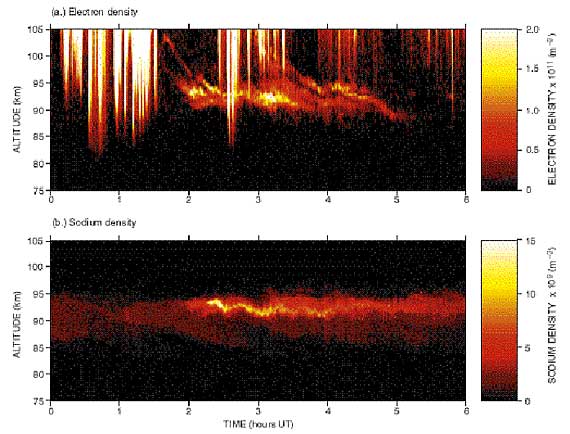
Upper Atmosphere Research. Research efforts in atmospheric sciences increasingly depend on the clustering of instrumentation to provide improved spatial coverage, better temporal and spatial resolution, and expanded measurement capabilities. An illustration of this trend is the combined lidar and incoherent scatter radar experiments being conducted at the Sondrestrom Facility in Greenland. The radar measurements of electron densities associated with thin ion layers along with simultaneous and coincident lidar measurements of the neutral sodium layer, offer new insights into the physical processes responsible for ion and neutral layering at high latitudes. The upper panel shows the sequence of incoherent scatter radar measurements in the altitude range from 80 to 110 km, with an altitude resolution of 600 meters. Thin ion layers appear to form at altitudes around 105 km and slowly descend to form a thicker aggregate layer around 93 km. The darker vertical streaks are electron density enhancements produced by aurora. The lower panel shows the presence of a thin sporadic sodium layer coincident with the ion layer and persisting for at least four hours. Clustering instrumentation at facilities, establishing strategically located chains of stations, and improving instrument capabilities all support studies of long-term environmental changes associated with global change and the prediction of atmospheric effects from weather and space weather. The data from these instruments provide information essential for the validation of models that simulate interaction between the various components of the Earth system. |
- Sample Collections4 Chemical, biological, and geological samples from specific research studies often retain value following the initial study. The insight from the initial study coupled with sample characterization, in fact, often enhances the value. Organized sample collections, or archives, with documented records accessible to additional investigators, are required to enable second-generation studies, including evaluation of long-term environmental changes. Geoscience collections include geological samples from the ODP, other field studies, and photographic archives from deep submersible science studies. Support for existing and possible new collections (e.g., lake drilling cores, continental drilling cores) is required with a focus on preserving collection integrity while expanding opportunities for additional research. This includes more extensive promotion and dissemination of information about the collections through internet and web-based communications.
- Unidata14 Unidata offers software and services that enable atmospheric scientists to acquire and use an extensive array of data products, often in real time. Unidata members constitute a nationwide collection of electronically-linked researchers having common academic interests in atmospheric and related sciences and sharing similar needs for data and software. Unidata permits users to benefit not only from the best contemporary software methods for accessing and displaying environmental data, but also from increased platform independence and greater use of distributed computing.
Future efforts should provide improved ease-of-use and greater compatibility with more data types and higher data volumes. In addition to adapting decoders and applications to analyze and display data, Unidata plans to expand the Internet Data Distribution system to incorporate new sources, handle higher data rates, adjust automatically to variations in user demands, adapt dynamically to Internet performance variations, and exploit networking advances such as multicast protocols. New capabilities would include animated, three-dimensional visualization tools and a Java-based information framework, setting the stage for eventually utilizing aggregate data holdings of all Unidata sites as a common community resource.
The mission of the Directorate for Geosciences (GEO) of the National Science Foundation (NSF) is to advance scientific knowledge about the solid Earth, freshwater, ocean, atmosphere, and geospace components of the integrated Earth system through support of high-quality research; through sustenance and enhancement of scientific capabilities; and through improved geoscience education (GEO Science Plan, 1998).
To fulfill its mission, GEO strives to attain three goals:
- advance fundamental knowledge about the Earth system;
- enhance the infrastructure used to conduct geoscience research; and
- improve the quality of geoscience education and training.
This document describes GEO's plan to achieve the second of these three goals over the next five years, and complements the GEO Science Plan, FY 1998-2002 (NSF 97-118).