
All Images
Research News
Communicating a hurricane's real risks

Static example of the experimental Potential Storm Surge Inundation Map, here for the Texas Gulf Coast, outside of Houston. The final product will be interactive with pan and zoom capabilities.
Credit: National Hurricane Center (NHC)
Download the high-resolution JPG version of the image. (878.6 KB)
Use your mouse to right-click (Mac users may need to Ctrl-click) the link above and choose the option that will save the file or target to your computer.
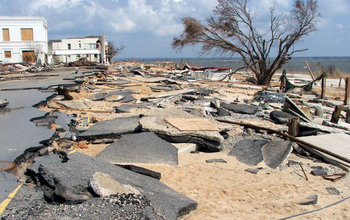
Storm surge damage at Bay St. Louis, Miss., after Hurricane Katrina. With support from a National Science Foundation grant, David Frost--professor of civil and environmental engineering at Georgia Institute of Technology, Savannah--organized three teams of researchers and graduate students to conduct week-long field studies to assess infrastructure damage in the Gulf Coast region in September and October 2005.
Credit: Image courtesy H. Fritz, Georgia Tech Savannah
Download the high-resolution JPG version of the image. (2.3 MB)
Use your mouse to right-click (Mac users may need to Ctrl-click) the link above and choose the option that will save the file or target to your computer.
_f.jpg)
The experimental storm surge watch/warning graphic will highlight those areas along the Gulf and Atlantic coasts of the United States that have a significant risk of life-threatening inundation by storm surge from a tropical cyclone. The new graphic is designed to introduce the concept of a watch or warning specific to the storm surge hazard.
Credit: National Hurricane Center
Download the high-resolution JPG version of the image. (582.6 KB)
Use your mouse to right-click (Mac users may need to Ctrl-click) the link above and choose the option that will save the file or target to your computer.