
All Images
Research News
Robots to the rescue

Researcher Robin Murphy studies robot-human interactions, including during disaster scenarios, using helper robots like this "Disaster Buddy."
Credit: Texas A&M University
Download the high-resolution JPG version of the image. (304.1 KB)
Use your mouse to right-click (Mac users may need to Ctrl-click) the link above and choose the option that will save the file or target to your computer.
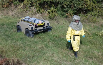
During the recent Ebola pandemic, Texas A&M University researcher Robin Murphy explored whether robots could help protect health workers from contagion in field hospitals in West Africa and in the U.S. Led by a trainer in a protective suit, the General Dynamics Land Systems MUTT was demonstrated as one way to use a robot to transport a patient.
Credit: Texas A&M University
Download the high-resolution JPG version of the image. (313.3 KB)
Use your mouse to right-click (Mac users may need to Ctrl-click) the link above and choose the option that will save the file or target to your computer.
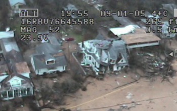
An UAV operated by Safety Security Rescue Research Center (SSRRC) team members captured this image of devastation in Pearlington, Miss., during a search for survivors of Hurricane Katrina. SSRRC is one of NSF's Industry-University Cooperative Research Centers.
Credit: Safety Security Rescue Research Center/National Science Foundation
Download the high-resolution JPG version of the image. (50.0 KB)
Use your mouse to right-click (Mac users may need to Ctrl-click) the link above and choose the option that will save the file or target to your computer.
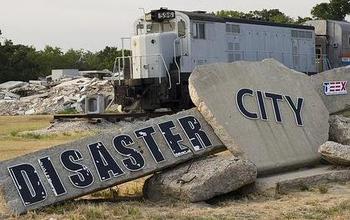
The sign that greets you at the entrance to Disaster City in College Station, Texas. Disaster City is where the Texas Engineering Extension Service (TEEX) is located and is one of the best emergency response training facilities in the world.
Credit: Texas Engineering Extension Service (TEEX)
Download the high-resolution JPG version of the image. (38.6 KB)
Use your mouse to right-click (Mac users may need to Ctrl-click) the link above and choose the option that will save the file or target to your computer.
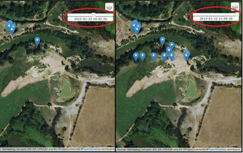
Abygail McMillian, a student at the University of North Georgia, created a program that visually displays where and when UAV data or any geotagged data was taken. She was a participant in a Research Experiences for Undergraduates (REU) program on Computing for Disasters, sponsored by NSF and led by Robin Murphy.
Credit: CRASAR
Download the high-resolution PNG version of the image. (6.2 MB)
Use your mouse to right-click (Mac users may need to Ctrl-click) the link above and choose the option that will save the file or target to your computer.