Return to Table of Contents
Rising ocean temperatures affect krill and other marine organisms
Will higher ocean temperatures cause antarctic ice shelves to thicken?
Antarctic whaling records suggest that the sea-ice cover has decreased
Science notebook--News from Antarctica and beyond
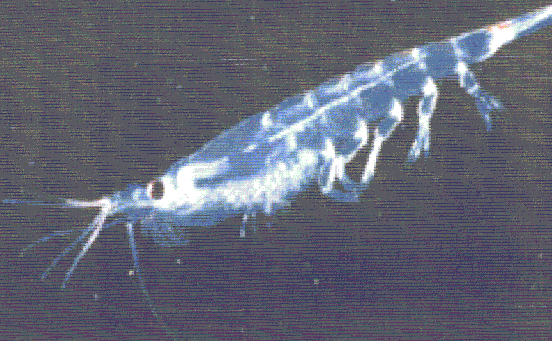
Rising ocean temperatures affect krill and other marine organisms
Krill (Euphausia superba) like cold winters. The small, shrimplike crustaceans feed on algae that grow on the underside of sea ice, so-according to an article in the 26 June 1997 issue of Nature-in years when cold weather prevails and the sea ice is extensive, krill populations thrive. In warmer years, their numbers shrink. Decreased populations of krill affect the entire antarctic food chain as well as commercial fishers who harvest them.
Valerie Loeb from Moss Landing Marine Laboratory in California worked with American and German colleagues to study the effect of fluctuating winter temperatures on the population of krill in the area around Elephant Island, just off the tip of the Antarctic Peninsula. The research team theorized that because, in general, winters in Antarctica have gotten warmer over the past 50 years-only one or two of every five recent winters produces extensive sea ice as compared to four out of every five winters 50 years ago-krill populations may be decreasing. Loeb and her fellow researchers found that, compared with counts done a decade ago, krill populations had decreased by a factor of 10.
Krill (Euphausia superba), despite their small size,
are a key link in the southern ocean food chain, contributing to its amazing
abundance. Fish, birds-including, of course, penguins-and whales all consume
large quantities of the shrimplike crustaceans. Even human fishers harvest
the krill to be cooked and peeled and made into sausage, fish paste, or livestock
feed. Because krill are so vital to the entire antarctic food chain, scientists
are monitoring the natural fluctuations in krill populations as well as the
impact of commercial harvesting.
Krill compete for algae with gelatinous creatures called salps. When there are fewer algae to go around, the competition is keen. In the years when salps thrive and krill decline, the effect on the rest of the food chain can be dramatic because many vertebrates that eat krill-fish, whales, and penguins, for example-won't eat salps instead.
Other marine biologists believe that the increased salp blooms may not curb krill populations. Robin Ross, a biological oceanographer from the University of California's Santa Barbara Marine Science Institute, notes that migration should be factored into the equation. "Centers of abundance in krill seem to shift from year to year," she comments.
Will higher ocean temperatures cause antarctic ice shelves to thicken?
On the face of it, it sounds like a contradiction, that the 2.5°C warming of the ocean, noted over the past 50 years, could actually reduce the rate of melting for antarctic sea ice. K.W. Nicholls, writing in the 31 July 1997 issue of Nature, however, purports that this contradiction is, in fact, what is happening beneath the FilchnerRonne Ice Shelf in the southern Weddell Sea near the Antarctic Peninsula.
Floating ice shelves, such as the FilchnerRonne, are sensitive to climate change on both their upper and lower surfaces. Nicholls took measurements to examine what is happening to the lower surface of the FilchnerRonne. Relatively warm (1.9°C) High Salinity Shelf Water (HSSW) forms north of the ice front at the seaward edge of the ice shelf. From the edge of the shelf, the HSSW flows beneath the shelf toward land until it reaches the base of the FilchnerRonne, where the huge ice mass attaches to the land mass. This influx of warmer water causes melting of this ice base.
Nicholls noted that summer conditions do not increase the temperature of the HSSW-it remains fixed at 1.9°C-but they do decrease the volume of HSSW that flows beneath the ice shelf. The reduced volume of the warmer water means a reduced influx of heat to the base of the ice shelf, so the ice thickens. "Seasonal warming," writes Nicholls in the Nature article, "results in a corresponding reduction in the melting at the base of the FilchnerRonne Ice Shelf.... To the extent that this is an analogue for a warming climate, it suggests that for as long as HSSW dominates the oceanographic conditions over the continental shelf, the response of the ice shelf to a warming climate will be for it to thicken, reinforcing rather than threatening its longevity."
Antarctic whaling records suggest that the sea-ice cover has decreased
William K. de la Mare, a climatologist from Tasmania, Australia, turned to a previously untapped source for long-term data about the behavior of sea ice around Antarctica. The International Whaling Commission maintains computerized records of 1.5 million whaling catches, every whale caught by factory ships in antarctic waters from 1931 to 1987, when commercial whaling there stopped. The whaler's logbooks note the precise latitude, longitude, date, and species for each catch. Because whales, especially the blue whale, are known to congregate near the ice edge, the records of the catches, de la Mare reasoned, should give a good indication of where the ice edge was on a particular day at a particular geographic point.
By combing the records and plotting what he found, de la Mare determined that the seasonal sea ice was constant until about 1954, when it began to shrink, ultimately reducing in size by 25 percent. It stabilized 19 years later and has stayed about the same from 1973 to the present. De la Mare published his findings in Nature.
Climatologists believe that the mass of the antarctic sea ice is a crucial factor regulating global climate. Whether the variation in the position of the ice edge indicated by the whaler's records is an indication of significant and long-term climate change or simply a natural cyclical variation, however, is unknown.
1997 ozone records
New Zealand researchers at Scott Base, Antarctica, report that this year's spring ozone hole was once again severe. The extent and depth of the ozone hole are about the same as each of the past 5 years: ozone is depleted by about 60 percent over levels before 1980. U.S. National Aeronautics and Space Administration satellite data show that the ozone depletion extends for 25 million square kilometers. In addition, unusual circulation patterns this year carried the ozone-poor air over New Zealand, although a threat to health is not indicated. An ozone monitoring facility in Central Otago, New Zealand, reported that on 10 August 1997, ozone levels were the lowest on record, 35 percent below normal.
Ozone readings at Scott Base dipped to 136 Dobson units, close to the lowest on record. Virtually all of the ozone between 14 and 20 kilometers altitude has been destroyed. Annually, the depletion peaks in October and levels return to normal by December.
The annual ozone depletion is expected to continue for the next 20 years despite the fact that international legislation has worked to phase out the use of ozone-depleting chlorofluorcarbons (CFCs). It will take 20 years, experts believe, for pollutants already released into the atmosphere to dissipate and for the damage to be reversed.
| Made using an orthographic projection looking down on the Earth from 60°S, this sequence of Southern Hemisphere images from 5 days in September, October, and November shows the spring ozone hole forming. Ozone values less than 225 Dobson units, indicated by violet colors, are termed the "ozone hole." The black circle in the middle of the 10 September image is due to polar night, when the total ozone mapping spectrometer (TOMS) cannot measure the ozone. This image, along with others, may be viewed as an animated gif at http://jwocky.gsfc.nasa.gov/eptoms/ep.html. The main link to the National Aeronautics and Space Administration's TOMS page is http://jwocky.gsfc.nasa.gov/. |
 |
 |
 |
 |
 |