
Multimedia Gallery
2010 spike in Greenland ice loss lifted bedrock
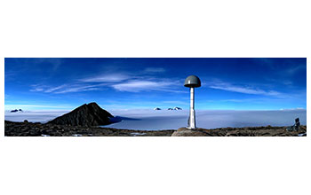
Composite photo of a Greenland GPS Network (GNET) GPS unit, used to measure ice sheet melting, implanted in the southeastern Greenland bedrock. The network is comprised of nearly 50 GPS stations planted along the Greenland coast to measure the bedrock’s natural response to the ever-diminishing weight of ice above it.
More about this image
An unusually hot melting season in 2010 accelerated ice loss in southern Greenland by 100 billion tons and large portions of the island's bedrock rose an additional quarter of an inch in response. These findings came from the GNET (the Greenland GPS Network) project, part of POLENET (The Polar Earth Observing Network), a global network dedicated to observing the polar regions in a changing world.
G-NET is a network of 46 continuous GPS stations spread across Greenland. The network is mapping the steady vertical velocity field associated with postglacial rebound and will improve the understanding of ice mass changes in Greenland, allowing scientists to quickly detect and analyze any abrupt changes in the rate of ice loss in this region.
In 2010, the southern half of Greenland lost an extra 100 billion tons of ice under conditions that scientists would consider anomalously warm. In scientific parlance, a melting day "anomaly" refers to the number of extra melting days -- that is, days that were warm enough to melt ice -- relative to the average number of melting days per year over several decades.
GNET measurements indicated that as that ice melted away, the bedrock beneath it rose. The amount of uplift differed from station to station, depending on how close the station was to regions where ice loss was greatest.
Southern Greenland stations that were very close to zones of heavy ice loss rose as much as 20 millimeters (about 0.79 inches) over five months. Even stations that were located far away typically rose at least 5 millimeters (0.2 inches) during the course of the 2010 melting season. But stations in the north of Greenland barely moved at all.
GNET is funded by the National Science Foundation. To learn more, see the Ohio State news story 2010 Spike in Greenland Ice Loss Lifted Bedrock, GPS Reveals. (Date image taken: unknown; date originally posted to NSF Multimedia Gallery: Dec. 22, 2017)
Credit: Image by Dana Caccamise; courtesy Ohio State University
Images and other media in the National Science Foundation Multimedia Gallery are available for use in print and electronic material by NSF employees, members of the media, university staff, teachers and the general public. All media in the gallery are intended for personal, educational and nonprofit/non-commercial use only.
Images credited to the National Science Foundation, a federal agency, are in the public domain. The images were created by employees of the United States Government as part of their official duties or prepared by contractors as "works for hire" for NSF. You may freely use NSF-credited images and, at your discretion, credit NSF with a "Courtesy: National Science Foundation" notation.
Additional information about general usage can be found in Conditions.
Also Available:
Download the high-resolution JPG version of the image. (4.0 MB)
Use your mouse to right-click (Mac users may need to Ctrl-click) the link above and choose the option that will save the file or target to your computer.