
Multimedia Gallery
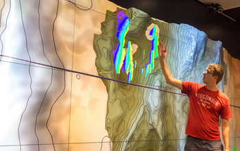
Sub-sea rift spills secrets to seismic probe (Image 2)
Rice University alumnus Brian Jordan, co-author of a new study on the Galicia margin based on an extensive seismic survey led by Rice, points out crustal faults that connect to the margin’s S-reflector. [See related image Here.]
More about this image
The first study from a Rice University-led 2013 international expedition to map the seafloor off the coast of Spain has revealed details about the evolution of the fault that separates the continental and oceanic plates.
The study describes the internal structure of a large, 3D section of the Galicia, a non-volcanic passive margin between Europe and the Atlantic basin that shows no signs of past volcanic activity and where the crust is remarkably thin. This thinness made it easier to capture 3D data for about 525 square miles of the Galicia, the first transition zone in the world to be analyzed in this manner.
Researchers used sophisticated seismic reflection tools to model the Galicia. The rift is buried under several hundreds of meters of powdered rock and invisible to optical instruments, but seismic tools fire sound into the formation, which bounce back, telling researchers what kind of rock lies underneath and how it’s configured.
The study produced the first seismic images of the S-reflector, a prominent detachment fault within the continent-ocean transition zone. Researchers believe this fault accommodated slipping along the zone in a way that helped keep the crust thin.
"The S-reflector, which has been studied since the '70s, is a very low-angle, normal fault, which means the slip happens due to extension," said Rice graduate student Nur Schuba. "What's interesting is that because it's at a low angle, it shouldn't be able to slip. But it did. One mechanism people have postulated is called the rolling hinge," she said. "The assumption is that an initially steep fault slipped over millions of years. Because the continental crust there is so thin, the material underneath it is hot and domed up in the middle. The initially steep fault started rolling and became almost horizontal.
"So with the help of the doming of the material coming from below and also the continuous slip, that’s how it is likely to have happened," she adds.
The research was supported in part by the National Science Foundation (NSF).
Read more in the NSF News From the Field story Sub-sea rift spills secrets to seismic probe. (Date image taken: 2018; date originally posted to NSF Multimedia Gallery: Aug. 10, 2018)
Credit: Photo by Gary Linkevich
Images and other media in the National Science Foundation Multimedia Gallery are available for use in print and electronic material by NSF employees, members of the media, university staff, teachers and the general public. All media in the gallery are intended for personal, educational and nonprofit/non-commercial use only.
Images credited to the National Science Foundation, a federal agency, are in the public domain. The images were created by employees of the United States Government as part of their official duties or prepared by contractors as "works for hire" for NSF. You may freely use NSF-credited images and, at your discretion, credit NSF with a "Courtesy: National Science Foundation" notation.
Additional information about general usage can be found in Conditions.
Also Available:
Download the high-resolution JPG version of the image. (1.3 MB)
Use your mouse to right-click (Mac users may need to Ctrl-click) the link above and choose the option that will save the file or target to your computer.