
Multimedia Gallery
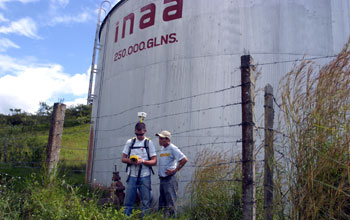
GPS Instruction
GPS Instruction
Michigan Technological University Aqua Terra Tech Enterprise student showing Moises Guillen, technical assistant for the Wisconsin/Nicaragua Partners of the Americas, how to determine locations using a GPS. In this instance, determining the location of a water tank for the distribution system for the city of Boaco, Nicaragua.
Aqua Terra Tech Enterprise's new project is aimed at creating water security in the small Nicaraguan town of Boaco. The rural community of 34,000 -- located in a country that for much of its recent past was embroiled in conflict with U.S.-backed warlords and still bears the economic scars -- relies on water from a polluted river and a single well.
Combined, these two sources are only able to supply about one-third of the community water supply, so residents have running water only a few hours per day, a couple of days per week. Getting more water is problematic because the underlying aquifers are in volcanic rock, so the production of a well depends on the density and distribution of subsurface fractures.
When fractures are far and few between, the water in a fracture is depleted quickly and refills slowly. As a result, of the 40 or so wells that have been drilled in the area, only two produce water that can significantly contribute to the city's needs. A solution for increasing the success of new wells: use the latest subsurface (geophysical) testing techniques to find more fractures for citing new wells. This December, Aqua Terra sent nine of its members to Nicaragua for twelve days. The team members studied the terrain and performed as many geophysical surveys as time and sight conditions permitted. The data collected will provide ample material to work with during the following semesters. The trip is made possible by a National Science Foundation grant (OISE 05-30109) that provides the team with the means to work on the project for the next five years, with annual trips to the project site. The Aqua Terra team hopes to accomplish similar projects in other areas facing water problems throughout Central America. (Date of Image: 2005) [One of 6 related images. See Next Image.]
Credit: Photo by Brian Parmeter, Courtesy Michigan Technological University
Images and other media in the National Science Foundation Multimedia Gallery are available for use in print and electronic material by NSF employees, members of the media, university staff, teachers and the general public. All media in the gallery are intended for personal, educational and nonprofit/non-commercial use only.
Images credited to the National Science Foundation, a federal agency, are in the public domain. The images were created by employees of the United States Government as part of their official duties or prepared by contractors as "works for hire" for NSF. You may freely use NSF-credited images and, at your discretion, credit NSF with a "Courtesy: National Science Foundation" notation.
Additional information about general usage can be found in Conditions.
Also Available:
Download the high-resolution JPG version of the image. (3.1 MB)
Use your mouse to right-click (Mac users may need to Ctrl-click) the link above and choose the option that will save the file or target to your computer.