
Multimedia Gallery
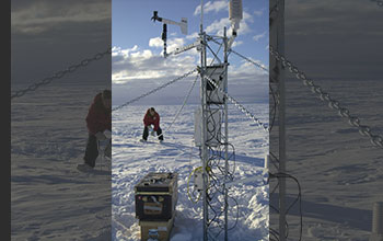
Research on Iceberg B-15A (Image 8)
Researchers from the University of Chicago and the University of Wisconsin install weather and global positioning systems instruments on iceberg B-15A. This was the first time an iceberg had been monitored like this, and the data will allow an unprecedented understanding of how giant bergs make their way through the waters of Antarctica and beyond.
More about this image
Iceberg B-15A, which is about 1,200-square-mile long, is a fragment of a much larger iceberg (B-15) that broke away from the Ross Ice Shelf in March 2000.
Scientists believe that the enormous piece of ice broke away as part of a long-term natural cycle (every 50 to 100 years or so) in which the shelf -- roughly the size of Texas -- sheds pieces, similar to human fingernails growing and breaking off. Researchers have been using global positioning system, weather monitoring stations and four seismometers on different icebergs to track them. The goal is to learn more about what causes icebergs to calve, how and why they drift, what happens when the icebergs warm, and why they are producing previously unknown tremors that are picked up on seismometers as far away as Tahiti.
Iceberg update: In 2005, prevailing currents took B-15A slowly past the Drygalski ice tongue (an iceberg located in northern McMurdo Sound). The collision broke off the tip of Drygalski in mid-April. Iceberg B-15A sailed on along the coast, leaving McMurdo Sound until it ran aground off Cape Adare in Victoria Land (a region of Antarctica lying south of New Zealand), where it broke into several smaller pieces on Oct. 27 and 28, 2005. The largest piece is still named B-15A (its surface is now approximately 1700 kilometers2), while three additional pieces were named B-15P, B-15M and B-15N. It has since moved farther up north and broken up into more pieces. These were spotted by an Air Force fisheries patrol on Nov. 3, 2006. On Nov. 21, several large pieces were seen just 60 kilometers off the coast of Timaru, New Zealand, with the largest measuring about 1.8 kilometers wide and 120 feet high. (Date of Image: Jan. 29, 2001) [Image 8 of 8 related images. Back to Image 1.]
Credit: Photo by Josh Landis, NSF
Images and other media in the National Science Foundation Multimedia Gallery are available for use in print and electronic material by NSF employees, members of the media, university staff, teachers and the general public. All media in the gallery are intended for personal, educational and nonprofit/non-commercial use only.
Images credited to the National Science Foundation, a federal agency, are in the public domain. The images were created by employees of the United States Government as part of their official duties or prepared by contractors as "works for hire" for NSF. You may freely use NSF-credited images and, at your discretion, credit NSF with a "Courtesy: National Science Foundation" notation.
Additional information about general usage can be found in Conditions.
Also Available:
Download the high-resolution JPG version of the image. (983.4 KB)
Use your mouse to right-click (Mac users may need to Ctrl-click) the link above and choose the option that will save the file or target to your computer.