
Multimedia Gallery
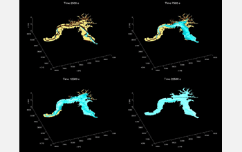
Numerical Simulation of Channel Flows (Image 2)
A numerical simulation of channel flows. Tidal currents fill up the Elkhorn Slough, on the coast of Monterey Bay, Calif. (time in seconds from low-low water). The water surface elevation inside Elkhorn Slough is determined by the tide. At low tides, the water surface elevation is low, so the mudflats on both sides of the channel are dry (see top-left pane). When high tide comes, water surface starts to rise, and sea-water flows into the slough, filling up the channel and spilling over onto the mudflats (see top-right to bottom-left panes). At high tide, the water surface elevation is high, and the mudflats are inundated (see bottom-right pane). In reality, the elevation of the mudflat bottom is not constant, and there are bumps and dips. But in this test run, the researchers used a constant elevation for the mudflat to simplify the problem. [Note: This figure was from a test run and a flat floodplain was used; the results are not accurate.] [Image 2 of 4 related images. See Image 3.]
More about this Image
Researchers Gang Zhao, Peter Ioannidis and Robert Street from the Environmental Fluid Mechanics Laboratory in the Civil and Environmental Engineering Department at Stanford University, used a 3-D numerical model--which simply speaking, is a computer program--to study the hydrodynamics of complex channel flows.
Understanding how water flows in channels is important for engineering projects, such as flood control, channel bank erosion control, and habitats restoration. The purpose of this study was to develop a numerical model and apply it to simulate complex channel flows. To learn more about the model, visit the SUNTAN (Stanford Unstructured Nonhydrostatic Terrain-following Adaptive Navier-Stokes Simulator) website.
The research team simulated the tidal currents in Elkhorn Slough, which is about 10 kilometers long and consists of a meandering main channel and a large area of mudflat and marsh. Elkhorn Slough has the second largest tidal salt marsh in California, which provides habitat for many plants and animals. However, the size of the salt marsh at Elkhorn Slough is decreasing due in part to tidal erosion. This simulation provides high-resolution velocity distribution inside the slough, which is a key step in understanding the hydrodynamics of the slough, and is important for future habitat conservation and restoration projects.
[This research was supported in part by National Science Foundation (NSF) grant 00-87842. Computations were performed at Stanford University's Center for Computational Earth and Environmental Science. SUNTAN is sponsored in part by NSF grant 01-13111.] (Date of Image: 2005)
Credit: Michael MacWilliams, Environmental Fluid Mechanics Laboratory, Stanford University
Images and other media in the National Science Foundation Multimedia Gallery are available for use in print and electronic material by NSF employees, members of the media, university staff, teachers and the general public. All media in the gallery are intended for personal, educational and nonprofit/non-commercial use only.
Images credited to the National Science Foundation, a federal agency, are in the public domain. The images were created by employees of the United States Government as part of their official duties or prepared by contractors as "works for hire" for NSF. You may freely use NSF-credited images and, at your discretion, credit NSF with a "Courtesy: National Science Foundation" notation.
Additional information about general usage can be found in Conditions.
Also Available:
Download the high-resolution JPG version of the image. (446 KB)
Use your mouse to right-click (Mac users may need to Ctrl-click) the link above and choose the option that will save the file or target to your computer.