
All Images
News Release 08-111
Lasers, Software and the Devil's Slide
New system lets engineers safely excavate roadway tunnel beneath landslide-prone stretch of California's Highway 1
This material is available primarily for archival purposes. Telephone numbers or other contact information may be out of date; please see current contact information at media contacts.
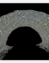
Point cloud of interior tunnel beneath Devil's Slide made with the tunnel laser scanning system and visualized with gVT.
Credit: Jeramy Decker, Kiewit Corp
Download the high-resolution JPG version of the image. (223 KB)
Use your mouse to right-click (Mac users may need to Ctrl-click) the link above and choose the option that will save the file or target to your computer.
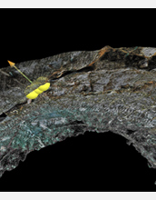
Close-up image of the tunnel roof showing a gVT measurement location. The arrow is a vector perpendicular to a surface that marks a discontinuity between rock layers. The orientation of the arrow in space gives the azimuth and slope of the surface.
Credit: Jeramy Decker, Kiewit Corp
Download the high-resolution JPG version of the image. (250 KB)
Use your mouse to right-click (Mac users may need to Ctrl-click) the link above and choose the option that will save the file or target to your computer.