
All Images
News Release 09-196
National Science Foundation Advisory Committee Offers New Vision for the Geosciences
Releases report: "GEO Vision: Unraveling Earth's Complexities through the Geosciences"
This material is available primarily for archival purposes. Telephone numbers or other contact information may be out of date; please see current contact information at media contacts.

NSF's Advisory Committee for Geosciences has released a new report: GEO Vision.
Credit: NSF Advisory Committee for Geosciences
Download the high-resolution JPG version of the image. (320 KB)
Use your mouse to right-click (Mac users may need to Ctrl-click) the link above and choose the option that will save the file or target to your computer.
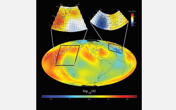
Geoscientists recently mapped Earth's global electrical conductivity in 3-D for the first time.
Credit: Anna Kelbert
Download the high-resolution JPG version of the image. (2 MB)
Use your mouse to right-click (Mac users may need to Ctrl-click) the link above and choose the option that will save the file or target to your computer.

Newly uncovered interactions between the Sun and the Earth affect our climate.
Credit: UCAR
Download the high-resolution JPG version of the image. (46 KB)
Use your mouse to right-click (Mac users may need to Ctrl-click) the link above and choose the option that will save the file or target to your computer.
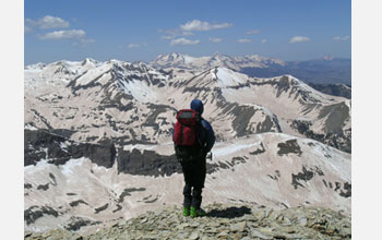
Increased desert dust blowing in the wind is altering mountain ecosystems.
Credit: Center for Snow and Avalanche Studies
Download the high-resolution JPG version of the image. (1.8 MB)
Use your mouse to right-click (Mac users may need to Ctrl-click) the link above and choose the option that will save the file or target to your computer.

Geoscientists are using instruments like the Doppler-on-Wheels to study tornado formation.
Credit: Josh Wurman, CSWR
Download the high-resolution JPG version of the image. (5.6 MB)
Use your mouse to right-click (Mac users may need to Ctrl-click) the link above and choose the option that will save the file or target to your computer.
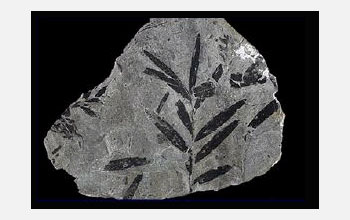
Ancient fossil leaves tell a story of sudden loss of biodiversity that may have current parallels.
Credit: John Weinstein, The Field Museum
Download the high-resolution JPG version of the image. (69 KB)
Use your mouse to right-click (Mac users may need to Ctrl-click) the link above and choose the option that will save the file or target to your computer.

An aerial view of Long Island shows its low-lying shores, vulnerable to rising sea-levels.
Credit: New York State Department of Environmental Conservation
Download the high-resolution JPG version of the image. (212 KB)
Use your mouse to right-click (Mac users may need to Ctrl-click) the link above and choose the option that will save the file or target to your computer.
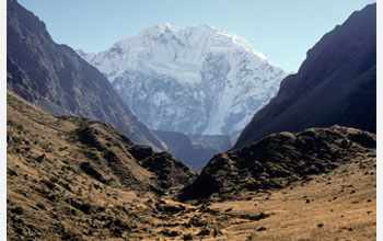
The history of glaciers in Peru and around the world is under study by geoscientists.
Credit: Joe Licciardi
Download the high-resolution JPG version of the image. (2 MB)
Use your mouse to right-click (Mac users may need to Ctrl-click) the link above and choose the option that will save the file or target to your computer.

The hybrid remotely operated vehicle Nereus may be tethered or untethered to a mother ship.
Credit: WHOI
Download the high-resolution JPG version of the image. (3 MB)
Use your mouse to right-click (Mac users may need to Ctrl-click) the link above and choose the option that will save the file or target to your computer.
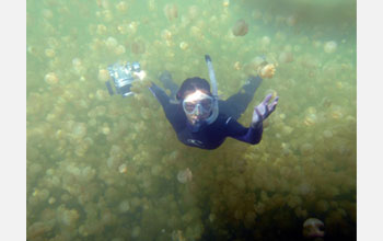
Jellyfish and other small sea creatures drive large-scale mixing in the oceans.
Credit: John Dabiri, Caltech
Download the high-resolution JPG version of the image. (880 KB)
Use your mouse to right-click (Mac users may need to Ctrl-click) the link above and choose the option that will save the file or target to your computer.

This artist's rendering shows the solar wind as it streaks by Earth.
Credit: NASA
Download the high-resolution JPG version of the image. (371 KB)
Use your mouse to right-click (Mac users may need to Ctrl-click) the link above and choose the option that will save the file or target to your computer.
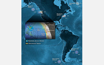
The locations of the new Ocean Observatories Initiative are shown in this graphic.
Credit: Center for Environmental Visualization, University of Washington
Download the high-resolution JPG version of the image. (4 MB)
Use your mouse to right-click (Mac users may need to Ctrl-click) the link above and choose the option that will save the file or target to your computer.

NSF EarthScope scientists have installed seismic stations across the continent.
Credit: EarthScope
Download the high-resolution JPG version of the image. (673 KB)
Use your mouse to right-click (Mac users may need to Ctrl-click) the link above and choose the option that will save the file or target to your computer.