
All Images
News Release 12-023
3-D Laser Map Shows Earthquake Zone Before and After
Geologists learn how earthquakes change the landscape--down to a few inches
This material is available primarily for archival purposes. Telephone numbers or other contact information may be out of date; please see current contact information at media contacts.

Post-earthquake topography shows Mexico's Pescadores Fault cutting along a ridge.
Credit: Michael Oskin et al., www.keckcaves.org
Download the high-resolution JPG version of the image. (569 KB)
Use your mouse to right-click (Mac users may need to Ctrl-click) the link above and choose the option that will save the file or target to your computer.

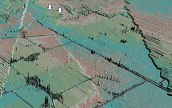
Mapped fault surface ruptures (black lines) mark breaks in the Earth's crust.
Credit: Michael Oskin et al., www.keckcaves.org
Download the high-resolution JPG version of the image. (631 KB)
Use your mouse to right-click (Mac users may need to Ctrl-click) the link above and choose the option that will save the file or target to your computer.

Small faults slice the ground and offset the desert floor around Mexico's Borrego Fault.
Credit: Michael Oskin et al., www.keckcaves.org
Download the high-resolution JPG version of the image. (678 KB)
Use your mouse to right-click (Mac users may need to Ctrl-click) the link above and choose the option that will save the file or target to your computer.

Earthquake surface ruptures cut and warp the ground in this 3-D post-quake rendering.
Credit: Michael Oskin et al., www.keckcaves.org
Download the high-resolution JPG version of the image. (513 KB)
Use your mouse to right-click (Mac users may need to Ctrl-click) the link above and choose the option that will save the file or target to your computer.
Agricultural fields and canals of the Colorado River delta after the earthquake.
Credit: Michael Oskin et al., www.keckcaves.org
Download the high-resolution JPG version of the image. (486 KB)
Use your mouse to right-click (Mac users may need to Ctrl-click) the link above and choose the option that will save the file or target to your computer.

A scarp dramatically offsets the ground along a fresh rupture of the Borrego Fault.
Credit: Michael Oskin et al., www.keckcaves.org
Download the high-resolution JPG version of the image. (669 KB)
Use your mouse to right-click (Mac users may need to Ctrl-click) the link above and choose the option that will save the file or target to your computer.

The researchers' work is described in the February 10, 2012 issue of the journal Science.
Credit: Copyright AAAS 2012
Download the high-resolution JPG version of the image. (1.1 MB)
Use your mouse to right-click (Mac users may need to Ctrl-click) the link above and choose the option that will save the file or target to your computer.