
All Images
News Release 13-197
Wetlands' ability to overcome sea level rise threatened
When do wetlands reach their limit, and how are we lowering that point?
This material is available primarily for archival purposes. Telephone numbers or other contact information may be out of date; please see current contact information at media contacts.
On this tidal marsh in Chesapeake Bay, wetlands and people have co-existed for millennia.
Credit: Matthew Kirwan
Download the high-resolution JPG version of the image. (388.0 KB)
Use your mouse to right-click (Mac users may need to Ctrl-click) the link above and choose the option that will save the file or target to your computer.

Scientist Matthew Kirwan conducts field research in Chesapeake Bay wetlands.
Credit: NSF VCR LTER Site
Download the high-resolution JPG version of the image. (2.6 MB)
Use your mouse to right-click (Mac users may need to Ctrl-click) the link above and choose the option that will save the file or target to your computer.

Salt marsh "dissected" by a tidal creek at NSF's Plum Island Ecosystems LTER site in Massachusetts.
Credit: Matthew Kirwan
Download the high-resolution JPG version of the image. (202.9 KB)
Use your mouse to right-click (Mac users may need to Ctrl-click) the link above and choose the option that will save the file or target to your computer.

High-elevation marsh at the Plum Island Ecosystems LTER site; flood-tolerant vegetation rules the day.
Credit: Matthew Kirwan
Download the high-resolution JPG version of the image. (197.7 KB)
Use your mouse to right-click (Mac users may need to Ctrl-click) the link above and choose the option that will save the file or target to your computer.

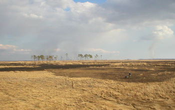
A fishing camp along Falgout Canal Bayou, La., where marsh has been flooded by seawater.
Credit: Matthew Kirwan
Download the high-resolution JPG version of the image. (172.0 KB)
Use your mouse to right-click (Mac users may need to Ctrl-click) the link above and choose the option that will save the file or target to your computer.

Some Massachusetts marshes formed after European settlement; deforestation increased sedimentation.
Credit: Matthew Kirwan
Download the high-resolution JPG version of the image. (185.3 KB)
Use your mouse to right-click (Mac users may need to Ctrl-click) the link above and choose the option that will save the file or target to your computer.