The surface area of the Earth, as a whole, is dominated by the ocean basins. Ocean crust is the most dynamic part of the solid Earth-encompassing 70% of Earth's surface area-and has been formed entirely in the last 5 percent of geologic time. As part of a continuous worldwide process, new ocean crust forms at ocean ridges and is destroyed in the deep ocean trenches. Despite its dominance, the ocean floor is largely unexplored and unmapped. Lack of detailed sea floor maps has limited the ability of scientists to address a range of basic questions about how the Earth works as an integrated system. Questions such as what happens when continents break apart, how does continental drift work, how does the ocean floor form, what controls the path of deep ocean currents, what kind of ecological niches exist in the oceans to harbor exotic life forms, and what processes work to shape the ocean floor are fundamental questions that must be answered to have a full understanding of our planet.
Recent advances in technology that uses sound waves to measure distance in water has led to remote sensing systems that can produce detailed sea floor maps. These systems use 120 beams to produce maps up to 15 kilometers wide along a ship track. This system is an enormous improvement over traditional methods, which were limited to single-depth profiles beneath the ship. The resulting maps provide an unprecedented view of undersea features, ranging from small-scale textures of the bottom deposits to underwater fault lines and undersea volcanoes. The sea floor mapping system on the Nathaniel B. Palmer allows researchers supported by the U.S. Antarctic Program to explore and map previously unknown regions.
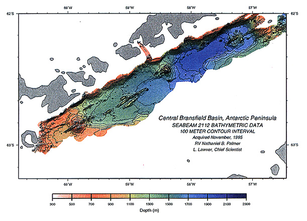
The map of the Bransfield Basin is an example of sea floor maps that are now available. This map was produced as part of a program to study how continents break apart to form an ocean basin and to search for evidence of active submarine hot springs. This project was under the direction of Dr. Lawrence Lawver (Institute for Geophysics at the University of Texas at Austin) and Dr. Gary Klinkhammer (Oregon State University). The region consists of continental crust that has been pulled apart, or rifted, as well as active volcanoes. Molten rock came up through the crust along straight faults to form linear ridges between large volcanoes. The bumpy surface near the volcanoes indicates the presence of mound-shaped hot spring deposits. All of these features are associated with an early stage in the birth of an ocean basin, and at no other place on Earth can one observe this stage of activity. Besides contributing to our general understanding of how ocean crust is formed, ocean basins, especially in their early stage of development, are hosts to major natural resource reserves, including both petroleum and mineral resources. Conse-quently, understanding the early development of ocean basins will lead to better models for exploration for natural resources elsewhere in the world. The mapping system was also used to pinpoint specific areas that might contain deep sea hot springs. At mid-latitude sites, such hot springs have been found to harbor unique and exotic communities of animals. The Bransfield Strait offers a potential high-latitude site for comparative studies that are needed to understand this new category of ecological system.