The Upper Atmosphere Research Program (UARP) in NASA's Office of Mission to Planet Earth supports laboratory research, field measurements, and process modeling to understand atmospheric chemical and transport processes from the upper troposphere to the stratosphere. These processes determine the chemical composition of each atmospheric region (especially regarding stratospheric ozone) and the relationship between chemical composition and climate.
Profound seasonal changes in the Antarctic atmosphere permit measurements that are significant to any global change strategy. UARP has funded balloon and ground-based measurements of stratospheric composition from the three U.S. stations in Antarctica (McMurdo, Palmer, and South Pole stations) and New Zealand's Scott Base. Such ground-based measurements are essential to the international Network for the Detection of Stratospheric Change (NDSC), supported in the United States by NASA and NOAA. Through NDSC, NASA funds various instruments, including a Fourier-transform infrared emission spectrometer at South Pole Station to measure total column abundances of nitric acid, ozone, nitrous oxide, methane, chloro-fluorocarbons, and chlorine nitrate, and a microwave instrument at Scott Base to measure profiles and column amounts of chlorine monoxide. Besides ground-based measurements, NASA investigators periodically launch balloons from McMurdo and Palmer stations during the austral spring.
The ice sheet. More than 70% of Earth's fresh water is bound up in the Antarctic ice sheets; if it all melted, global sea level would rise some 70 meters. Over the past century, sea level appears to have risen more than 1 mm per year, with rates possibly increasing over the past 40 years. Thermal expansion of the ocean and gradual melting of small glaciers and ice caps partially explain this rise. Although the polar ice sheets are the obvious sources for the missing water, we still do not know whether the ice sheets in Greenland and Antarctica are growing or shrinking. Consequently, a major goal of NASA's polar research program is to measure the change in volume of these ice sheets.
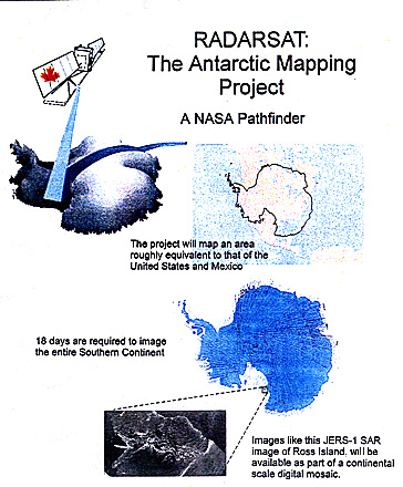
In 2002 NASA plans to launch the first of a series of satellite laser altimeters to measure directly ice-sheet surface elevation and elevation change over Greenland and most of Antarctica. In addition, the first high-resolution map of Antarctica will be compiled from Synthetic Aperture Radar (SAR) data acquired by the Canadian RADARSAT mission, which NASA launched in November 1995. The resulting maps will show the ice-sheet dynamics in unprecedented detail and will provide baseline data against which future maps can be compared to reveal ice-sheet changes.
To support the satellite measurements, NASA and NSF have established a SAR receiving station at McMurdo Station and radar transponders to calibrate the SAR images at McMurdo and South Pole stations. Data are sent to the NASA-supported SAR facility at the University of Alaska, Fairbanks, for reduction and distribution. NSF supports complementary ground-based studies, such as those by Martin Jeffries of the University of Alaska, on the processes that might be responsible for changes seen in the satellite data.