Unprecedented detail of a massive continent
International effort pays off to chart the last unmapped regions on Earth
RADARSAT: Making a digital mosaic of Antarctica
Unprecedented detail of a massive continent
For about 18 days in September and October 1997, RADARSAT took over 5,000 digital synthetic aperture radar (SAR) images of Antarctica, a region the size of Canada and Alaska combined. Over the next 1 1/2 years, the Byrd Polar Research Center of Ohio State University will use the data gathered by RADARSAT to produce a high-resolution mosaic of the entire continent. Byrd cartographers have dubbed the project "RADARSAT: The Antarctic Mapping Project," or RAMP.The RADARSAT-based map will not only help scientists understand the dynamics of the antarctic ice sheets but also will provide them with a benchmark for testing the predicted effects of global warming on Antarctica's ice and for determining the effects of human activity on the continent. Antarctica holds nearly 70 percent of the Earth's freshwater, so changes in this enormous reservoir directly influence world sea level and climate; monitoring changes is vital. Using the RADARSAT data, scientists will be able to examine, at high resolution and on a continent-wide scale, the effects of complex climatological, glaciological, and geological processes on Antarctica.
Initial images reveal details of antarctic ice streams and crevices as well as of the old, long-buried aircraft runway and structural remains of the international South Pole research station established in the 1950s. The image of the old station and several other images are available on the Internet at http://radarsat.space.gc.ca and http://radarsat.space.gc.ca/ENG/AMM/amstn.html. RADARSAT is capable of acquiring high-resolution images of Earth's surface day or night and under all weather conditions--even under conditions of smoke, haze, and smog. It can capture images as wide as 500 kilometers and can detect objects as small as 8 meters.
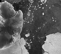 |
Bear Peninsula, Smith Glacier, and a portion of the Thwaites Glacier located in Pine Island Bay (106°W 75°S) are shown in this RADARSAT image. This region was first mapped during the late 1940s as part of Operation High Jump, which included participation by Admiral Richard Byrd. Thwaites Glacier drains about 7 percent of the interior east antarctic ice sheet. It reaches a velocity of nearly 3 kilometers per year. |

Both the old and new facilities are visible in this RADARSAT image of Amundsen-Scott South Pole Station. |
International effort pays off to chart the last unmapped regions on Earth
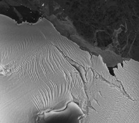
On 4 November 1995, NASA launched the Canadian satellite from Vandenberg Air Force Base. In exchange for NASA's launching of RADARSAT, Canada agreed to provide U.S. scientists with a proportionate amount of the data gathered and to execute a yaw maneuver that would put the normally right-looking satellite into what mapper's termed the "Antarctic Mode"; a 180° rotation to allow the radar to image to the left of the satellite track. Earlier satellites could not get an image of the entire continent because of their orbit inclinations, their field of view, or both.| The coast of Princess Elizabeth Land in East Antarctica is shown in this RADARSAT image. An enormous tongue of glacial ice (about 20 kilometers long) has broken off from a glacier and formed a serrated iceberg. Glacier flow patterns are clearly evident. |  |
Although the United States and Canada were the primary collaborators in this effort, support from the international science community has been invaluable. "The job of mapping one of the last largely unexplored regions of the Earth is truly a mission of international collaboration that includes scientists from Great Britain, Germany, Japan, and Australia in addition to the United States and Canada," said Kenneth Jezek, a professor of geological science and director of the Byrd Polar Research Center. "In that way, the Antarctic Mapping Mission is in keeping with the spirit and intent of the Antarctic Treaty, which serves to preserve the continent for peaceful scientific research by any nation."
 |
Bear Peninsula, Smith Glacier, and a portion of the Thwaites Glacier located in Pine Island Bay (106°W 75°S) are shown in this RADARSAT image. This region was first mapped during the late 1940s as part of Operation High Jump, which included participation by Admiral Richard Byrd. Thwaites Glacier drains about 7 percent of the interior east antarctic ice sheet. It reaches a velocity of nearly 3 kilometers per year. |