
Multimedia Gallery
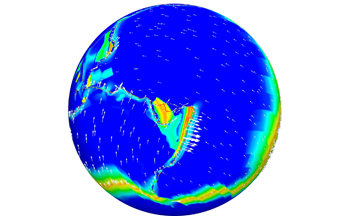
XSEDE can enhance earthquake research with better tools that map movement of the Earth's mantle.
TeraGrid simulations map the movement of the Earth's mantle for greater insight into earthquakes. Tectonic plate motion is represented by arrows, with viscosity arising from global mantle flow simulation. Plate boundaries, which can be seen as narrow red lines above insert are resolved using an adaptively refined mesh with 1km local resolution. Shown are the Pacific and the Australian tectonic plates and the New Hebrides and Tonga microplates. XSEDE will enable the same kind of work, but will provide greater precision, more detail, and new knowledge.
Credit: Georg Stadler, Institute for Computational Engineering & Sciences, The University of Texas at Austin
Images credited to the National Science Foundation, a federal agency, are in the public domain. The images were created by employees of the United States Government as part of their official duties or prepared by contractors as "works for hire" for NSF. You may freely use NSF-credited images and, at your discretion, credit NSF with a "Courtesy: National Science Foundation" notation.
Additional information about general usage can be found in Conditions.
Also Available:
Download the high-resolution JPG version of the image. (371 KB)
Use your mouse to right-click (Mac users may need to Ctrl-click) the link above and choose the option that will save the file or target to your computer.
Related story: XSEDE Project Brings Advanced Cyberinfrastructure, Digital Services and Expertise to Nation's Scientists and Engineers