
Multimedia Gallery
Dino Footprints Discovered in Arkansas
(Image 11)
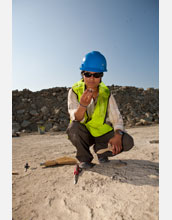
Boise State University researcher Celina Suarez examines a rock found at a newly discovered site in southwestern Arkansas littered with dinosaur tracks. Suarez and researchers from the University of Arkansas will use rocks found at the site to study the paleoclimate of the Early Cretaceous period. [Image 11 of 12 related images. See Image 12.]
More about this Image
Researchers have discovered a site in southwestern Arkansas the size of two football fields that contains dinosaur tracks from a number of species, some of which have not been previously identified in Arkansas.
With support from a fast-track grant from the National Science Foundation, the University of Arkansas (UA) and the J. William Fulbright College of Arts and Sciences, a team of researchers led by Stephen K. Boss, a geosciences professor at UA, spent two weeks studying the site, which is on privately owned land. "The quality of the tracks and the length of the trackways make this an important site," said Boss.
In addition to learning more about the animals themselves, the researchers hope to learn more about the environment in the area during the Early Cretaceous period, 115 to 120 million years ago. Based on the rock in which the footprints were found, the researchers have a good idea of what the climate would have been like. According to Boss, it was comparable to the shores of the Persian Gulf today, with hot air temperatures, shallow and salty water and a harsh environment. "We're not sure what the animals were doing here, but clearly they were here in some abundance," he says.
Among the discoveries at the site are the tracks of a three-toed dinosaur whose footprint measures about 2 feet long by 1 foot wide--possibly from an Acrocanthosaurus atokensis, one of the largest predators to ever walk the Earth; and giant prints from sauropods such as Pleurocoelus and Paluxysaurus, large, long-necked dinosaurs that ate plants. The site is littered with other, as yet unidentified prints that researchers will analyze in the future.
To examine the site, the scientists used a mix of traditional tools, such as chisels, hand-held brooms and plaster, and cutting-edge technology: Specifically, LIDAR--light detection and ranging. Jackson Cothren and Malcolm Williamson, researchers from the department of geosciences and the Center for Advanced Spatial Technologies at UA, used LIDAR to create a highly accurate map of the tracks at the site. They took detailed measurements of the trackways from the ground and looking down on the site from a ridge above. The data gathered will help them learn more about dinosaur biomechanics, the animals' identities and their movements and behaviors.
"It's critical to scan and document these tracks because once you expose the stone it will erode away," said Williamson. "In the past, people would take photographs to document site areas and tracks, but the dimensions aren't always accurate and it's hard to capture a lot of the details."
The existence of the footprints tells researchers that the surface was exposed to the elements at one time. Data collected from this site and others will aid them in reconstructing the regional paleoclimate during the Early Cretaceous period, including the frequency of rain and the amount of evaporation that affected the area 120 million years ago. Such information may be useful in making predictions about the Earth's future climate.
"This site will add to the knowledge of both the animals and climate of the Early Cretaceous," Boss said. "Scientists will be studying these data for many years." (Date of Image: July 2011)
Credit: Russell Cothren, University of Arkansas
Images and other media in the National Science Foundation Multimedia Gallery are available for use in print and electronic material by NSF employees, members of the media, university staff, teachers and the general public. All media in the gallery are intended for personal, educational and nonprofit/non-commercial use only.
Images credited to the National Science Foundation, a federal agency, are in the public domain. The images were created by employees of the United States Government as part of their official duties or prepared by contractors as "works for hire" for NSF. You may freely use NSF-credited images and, at your discretion, credit NSF with a "Courtesy: National Science Foundation" notation.
Additional information about general usage can be found in Conditions.
Also Available:
Download the high-resolution JPG version of the image. (2.6 MB)
Use your mouse to right-click (Mac users may need to Ctrl-click) the link above and choose the option that will save the file or target to your computer.