
Media Advisory 11-018
Hazards Researchers to Take Capitol Hill "By Storm"
Expo to show how basic science and engineering research facilitates local, state, federal and private-sector capability to predict, prepare for, mitigate and respond to disasters
Basic science may assist in hazard preparedness and response and recovery.
September 6, 2011
This material is available primarily for archival purposes. Telephone numbers or other contact information may be out of date; please see current contact information at media contacts.
The National Science Foundation (NSF) will host an expo featuring interactive demonstrations and research findings that showcase science and engineering discovery, technologies and tools that have practical application to hazards. More than 30 research exhibitor teams will show how their NSF-supported work impacts and enables policymakers and disaster responders to better predict, prepare for, mitigate and respond to significant hazards that affect life, property, societal infrastructure and natural assets.
The exhibits will demonstrate research relating to tornados, earthquakes, tsunamis, volcanoes, oil spills and hurricanes, as well as the human response to these events. Walk-through exhibits will include: an earthquake simulator, tornado pods, search-and-rescue robots, a flood flume, 3-D IMAX clips from Tornado Alley, unmanned aerial vehicles for rescue and more. The event is made possible by the American Geophysical Union and the Congressional Hazards Caucus.
| What: | National Science Foundation Hazards Research Expo |
| Who: | Dr. Subra Suresh, NSF Director Senate Majority Leader Harry Reid Sen. Bill Nelson, Fla. Sen. Kay Bailey Hutchison, Texas Sen. Mary Landrieu, La. (invited) |
| When: | Sept. 7, 10:30 am EDT |
| Where: | Hart Senate Office Building, Room 902 Constitution Avenue and 2nd Street, NE Washington, DC |
-NSF-
Which Hazards Are in Your Backyard?
A NATIONAL SCIENCE FOUNDATION HAZARDS RESEARCH EXPO
Tuesday, September 6, 2011, 2:00 - 4:00 pm
National Science Foundation, Rooms 110, 120, & Atrium
Active Earth Kiosk - EarthScope
Matt Fouch, Department of Terrestrial Magnetism, Carnegie Institution of Washington, DC & Ariz.
Wendy Bohon, PhD Student, Arizona State University, Ariz.
EarthScope studies the North American continent and the processes that lead to the development of earthquakes and volcanic eruptions. The exhibit includes an Active Earth Kiosk, a highly interactive and exciting teaching tool that incorporates recent seismic data into visualizations. This kiosk is easily navigated and provides thought-provoking content for the public and trained professional scientists, alike.
Water Simulation
Dave D. White, Arizona State University, Ariz.
Lauren Withycombe Keeler, Graduate Student, Arizona State University, Ariz.
Liz Marquez, Arizona State University, Ariz.
Water is a limited resource in the Phoenix area. This exhibit displays an interactive visualization on water supply and a water simulator to show assessments of water availability there. This activity will be interactive and allow visitors to adjust controls that impact water supply based upon various activities.
Cascadia: Earthquake and Tsunami Hazard off Oregon, Washington and Northern California: A Ticking Time Bomb
Costas Synolakis, University of Southern California, Calif.
Harold Tobin, University of Wisconsin-Madison, Wis.
Alison Henning, GeoPRISMS Program, Rice University, Texas
Maya Tolstoy, Lamont Doherty Earth Observatory at Columbia, N.Y.
Donna Shillington, Lamont Doherty Earth Observatory at Columbia, N.Y.
This group of displays, animations, videos, and simulations explores the topic of earthquake and tsunami hazards in the ocean off the coasts of Oregon, Washington, and northern California. This physical situation is comparable to that found off of northern Japan, where the calamitous events of March 11, 2011, occurred. The U.S. Pacific Northwest is at serious risk for such a large earthquake and tsunami, and more research is needed to protect the at-risk populations and facilities in this area.
Fire and Urban Outreach
Terri Hogue, University of California Los Angeles (UCLA), Calif.
Alicia Kinoshita, PhD Student, UCLA, Calif.
This research team has expertise in communicating the importance of droughts, floods, urbanization and wildfires to wide audiences, including school children and the public. The display features stream water samples taken in the first rain after a burn event to reveal the impact of burning on the water supply. This research focuses on the need for fire, drought, and urbanization to be viewed and investigated as a complete system.
Simulations of Earthquakes in Southern California (SCEC)
Greg Beroza, SCEC, Calif.
Marine Denolle, Stanford University, Calif.
Mark Benthion, University of Southern California, Calif.
The SCEC is a joint NSF and U.S. Geological Survey initiative to advance the understanding of earthquakes and to mitigate their associated risks. This exhibit will include a computer display of various Southern California earthquake simulations. Visitors to this booth will be able to create their own earthquake simulations and seismic readings.
Using Images to Predict Disaster Severity
Ronald Eguchi, ImageCat, Calif.
Luke Barrington, Tomnod, Inc., Calif.
This exhibit demonstrates how the extent of building damage after an extreme event may predict the severity of disruption to a community's social fabric and economic function. In addition, the exhibit explains how "crowd sourcing" has been used to map the extent of damage in several recent, devastating events. The researchers are beginning to correlate this data with measures of community disruption and recovery. In the future, this approach may allow emergency response and management organizations to predict and mitigate the effects of the worst disasters. The display includes an unmanned helicopter used to collect images.
National Center for Atmospheric Research
Rebecca Morss, National Center for Atmospheric Research, Colo.
Chris Davis, National Center for Atmospheric Research, Colo.
The exhibit by the National Center for Atmospheric Research (NCAR) displays the output of numerical weather prediction models and is an exciting way to convey the progress science has made in the timely prediction of hazardous phenomena. Animations of forecasts of severe convective storms, hurricanes and snow storms with verification data shown side-by-side are on display.
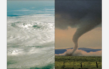
Severe Weather Research Featuring Tornado Pods
Josh Wurman, Center for Severe Weather Research (CSWR), Colo.
Karen Kosiba, Center for Severe Weather Research (CSWR), Colo.
This exhibit features "tornado pods," ruggedized weather stations deployed inside hurricanes and tornadoes. The exhibitors are also well known for their work with "Doppler on Wheels," a fleet of radar-equipped trucks collecting detailed information on severe weather processes. These scientists have appeared in Storm Chasers on the Discovery Channel and in several documentaries on National Geographic, PBS, History Channel, BBC and NHK.
Tripod Laser Scanner, GPS Receiver, Tiltmeter - UNAVCO
Jim Normandeau, Project Manager, UNAVCO, Colo.
Megan Berg, E&O Generalist, UNAVCO, Colo.
Ashley Grijalva, RESESS Intern/UNAVCO, University of Texas-El Paso, Texas
The exhibit from UNAVCO of Boulder showcases a tripod that projects a scanning view of the room as well as a vinyl floor map of the San Andreas Fault system and Los Angeles basin. A GPS sits on this map and provides visitors with the opportunity to interact and ask questions.
Unmanned Aerial Vehicles Exhibit
Eric Frew, University of Colorado, Boulder, Colo.
Brian Argrow, University of Colorado, Boulder, Colo.
Maciej Stachura, Graduate Student, University of Colorado-Boulder, Colo.
This exhibit showcases a remotely controlled unmanned aircraft vehicle. These unmanned aircraft are deployed in severe weather to provide rescuers with a broad overview of the impacts of severe weather in a given area.
Global Seismic Network
Bob Woodward, IRIS, Washington, DC
John Taber, IRIS, Washington, DC
Perle Dorr, IRIS, Washington, DC
Patrick McQuillan, IRIS, Washington, DC
Ray Willemann, IRIS, Washington, DC
Olga Cabello, IRIS, Washington, DC
Jennifer Tarnowski, PASSCAL Intern/New Mexico Tech, N.M.
James Gridley, PASSCAL Program Manager, IRIS, N.M.
Kent Anderson, IRIS, N.M.
John Hole, Virginia Tech, Va.
Emily Wolin, Graduate Student, Northwestern University, Ill.
Incorporated Research Institutions for Seismology (IRIS) is a consortium of more than 100 U.S. universities dedicated to the operation of science facilities for the acquisition, management and distribution of seismological data. The IRIS exhibit includes interactive activities and a display of seismic instrumentation and associated equipment. They also exhibit the National Geographic video X-Ray Earth, which features the Transportable Array.
Deep Water Horizon Oil Spill - What Happened to the Plume?
Tamay Ozgokmen, University of Miami, Fla.
This exhibit showcases results from a modeling effort of the Deep Water Horizon oil-gas plume and its dispersion, and it features stunning visualizations of numerical simulations from this research.
Hurricane Evacuation Project
Kenneth Broad, University of Florida, Miami, Fla.
Ben Orlove, Columbia University, N.Y.
Julia Wester, Student
Robert J. Meyer, University of Pennsylvania, Pa.
Katherine Thompson, PhD Student, Columbia University, N.Y.
This research focuses on effective communication of hurricane information. The exhibit includes a hurricane simulation featuring footage from strong hurricanes. This interactive activity includes the ability for visitors to enter their state or congressional district data and view the likely risks associated with hurricanes for that area.
3D-IMAX Film Tornado Alley
Deborah Raksany, Director of Strategic Partnerships, Giant Screen Films, Ill.
This exhibit includes 3D clips of the IMAX Film Tornado Alley. It also includes hands-on activities to showcase our understanding of tornadoes and other natural disasters.
Network for Earthquake Engineering Simulation
Keith Adams, Purdue, Ind.
Ali Irmak Ozdagli, Purdue, Ind.
Julio Ramirez, Purdue, Ind.
Mehdi Saiidi, University of Nevada-Reno, Nev.
The Network for Earthquake Engineering Simulation (NEES) exhibit features impressive video of a large-scale NEES experiment and a hands-on activity related to laboratory research. The video shows a recent test on the NEES shake tables at the University of Nevada, Reno Harry Reid Laboratories. A 110-ft-long, four-span bridge built using pioneering quick construction methods shook with simulated ground motions three times larger than the devastating 1994 Northridge earthquake. The hands-on activity features a mini-shake table and new devices that dissipate energy to reduce the motion of a building during an earthquake.
The Human Health Impact of Hurricanes Rita and Katrina in the New Orleans Area
Ed Laws, Louisiana State University, La.
This exhibit shows the human health impact of hurricanes Rita and Katrina in the New Orleans area. The research team's display reflects the many threats to human health associated with hurricanes in Louisiana.
River on the Road
Peter Wilcock, Johns Hopkins University, Md.
Barbara Burkholder, National Center for Earth-surface Dynamics, Minn.
Stephanie Day, St. Anthony Falls Laboratory, University of Minnesota, Minn.
Efi Foufoula-Georgiou, Director, National Center for Earth-surface Dynamics, Minn.
The research team for River on the Road presents a 5'-by-3' flume that allows scientists to reproduce floods and other hazards. River on the Road allows for hands-on interaction with flumes and flume science.
The Fate of the Oil from the Deep Water Horizon Oil Spill
Chris Reddy, Woods Hole Oceanographic Institution, MA
A leading authority regarding the fate of the oil from the Deep Water Horizon oil spill, Chris Reddy, exhibits some of the hardware used to sample the subsurface oil as well as debris from the Deep Water Horizon rig. He also shows water-oil samples and discusses his oil spill work with visitors who wish to learn more about this man-made disaster.
Space Weather
Thomas Zurbuchen, University of Michigan, Mich.
Susan Lepri, Research Scientist, University of Michigan, Mich.
Dan Gershman, PhD Student, University of Michigan, Mich.
Whitney Nudo, Undergraduate Student, University of Michigan, Mich.
The Space Weather exhibit includes visualizations and actual field-deployed hardware to demonstrate the impacts of space weather on people's lives. The team will also have some sound samples such as whistlers and radio perturbations. Additionally, a student who has won awards by turning space weather data into music through
Community Recovery and Resilience after Disaster
Himanshu Grover, University at Buffalo, N.Y.
Samuel (Sam) Brody, Texas A&M University, Texas
This exhibit demonstrates the interactive Texas Coastal Communities Planning Atlas, a web-based geographic information system that allows anyone with an Internet connection to see the potential consequences of living on the coast. The Atlas is built on scientific data and findings concerning the physical, environmental, policy and social patterns present along the Texas Coast, which is subject to hurricanes and other extreme weather events. The Atlas includes data on hazard vulnerabilities, impact and recovery over several years, and can isolate data for a particular community, neighborhood, or even a home.
Connectivity to Climate Change Environmental Network (EPSCoR)
Graham Kent, Director, Seismology Laboratory, University of Nevada-Reno
Annie Kell, Student, University of Nevada-Reno
The researcher is partnering with the Nevada EPSCoR Track 1 project to provide essential connectivity for remote connection to the Climate Change environmental network.
Hurricane Predictions
Isaac Ginis, University of Rhode Island, RI
This exhibit will showcase research on hurricane prediction and show simulations of the recent Hurricane Irene and the web site on Hurricane Science and Society.
How People Respond to Hazards
Susan Cutter, Director, Hazards & Vulnerability Research Institute, University of South Carolina, S.C.
Research on how people respond to hazards is presented in the form of a poster and interactive conversations.
Hurricane Evacuation Simulations
Donald H. House, Clemson University, S.C.
Mike Lindell, Texas A&M, Texas
Hurricane evacuation simulations in this exhibit shows how new data software improves evacuation strategies. The team also has a new kind of hurricane track forecast that utilizes household surveys and other sources of pivotal data.
Designing Critical Infrastructure for Multiple Threats
Jamie Padgett, Rice University, Texas
Leonardo Dueñas-Osorio, Rice University, Texas
Our nation's critical infrastructure systems face threats from aging and deterioration, increasing demand by a growing population, natural hazards such as earthquakes and hurricanes, and other sources. These threats often result not only in physical damage but in cascading failures across distinct interdependent systems, as well as in social, environmental, and economic impacts that impair resilience and sustainability. This exhibit shares images of utility systems and bridges before and after extreme events and demonstrates an online tool that calculates risk to infrastructure for different hazard scenarios.
Flash Floods
Witek Krajewski, Iowa Flood Center, University of Iowa, Iowa
Larry J. Weber, University of Iowa, Iowa
Fernando Salas, University of Texas-Austin, Texas
Tim Whiteaker, University of Texas-Austin, Texas
The Consortium of Universities for the Advancement of Hydrologic Science, Inc., (CUAHSI) developed the widely used and respected Hydrologic Information System (HIS). They showcase the flash flood tool that involves the IBM-Austin research group. This exhibit includes videos and pop-up banners.
Robots to the Rescue
Robin Murphy, Computer Science & Engineering, Texas A&M, Texas
Brittany Duncan, NSF Graduate Fellow, Computer Science & Engineering, Texas A&M, Texas
Jesus Suarez, NSF LSAMP Graduate Fellow, Computer Science & Engineering, Texas A&M, Texas
Rescue robots serve as a trapped disaster victim's lifeline to the outside world. Robin Murphy, a founder in the field of rescue robots, and her collaborators have designed ground, air, and sea robots for urban search and rescue, which have been utilized at 11 disasters, including the 9/11 World Trade Center disaster, Hurricanes Katrina and Charley, and the Crandall Canyon Utah mine collapse. One of her most recent projects supported by NSF took her robots to Japan for remote assessment and situation awareness for critical life saving and recovery operations in the aftermath of the Sendai earthquake and tsunami. Her exhibit showcases examples of robots designed by her and her team and also includes footage from the Japan disaster response and other responses such as on 9/11.
Tornado Behavior Research
David Lewellen, West Virginia University, W.Va.
Observations and simulation studies have demonstrated a great variety and complexity of tornado behavior. This study focuses on tornado-surface interactions and their effects on tornado intensification and structure. A long-term goal of the research is better understanding of tornado occurrence and behaviour in order to improve tornado prediction and increase public safety.
Featured Speakers
Greg Beroza, Professor of Geophysics at Stanford University and Deputy Director of the Southern California Earthquake Center; Sponsored by the NSF Directorate for Geosciences
Susan Cutter, Director, Hazards & Vulnerability Research Institute, University of South Carolina, SC; Sponsored by the NSF Directorate for Social, Behavioral, and Economic Sciences
Ann Kierjmedjian, Professor of Engineering at Stanford University; Sponsored by the NSF Directorate for Engineering
Co-Sponsors/Hosts
American Geophysical Union - AGU
Chris McEntee
Executive Director/CEO
American Geophysical Union
Woodrow Wilson Center
Lea Shanley
Senior Associate
Science and Technology Innovation Program
Woodrow Wilson International Center for Scholars
Hazards Caucus Alliance
Linda Rowan
Government Affairs Director
American Geological Institute
Media Contacts
Deborah Wing, NSF, (703) 292-5344, email: dwing@nsf.gov
Cheryl L. Dybas, NSF, (703) 292-7734, email: cdybas@nsf.gov
Program Contacts
Neysa Call, NSF, (703) 292-8430, email: ncall@nsf.gov
The U.S. National Science Foundation propels the nation forward by advancing fundamental research in all fields of science and engineering. NSF supports research and people by providing facilities, instruments and funding to support their ingenuity and sustain the U.S. as a global leader in research and innovation. With a fiscal year 2023 budget of $9.5 billion, NSF funds reach all 50 states through grants to nearly 2,000 colleges, universities and institutions. Each year, NSF receives more than 40,000 competitive proposals and makes about 11,000 new awards. Those awards include support for cooperative research with industry, Arctic and Antarctic research and operations, and U.S. participation in international scientific efforts.
Connect with us online
NSF website: nsf.gov
NSF News: nsf.gov/news
For News Media: nsf.gov/news/newsroom
Statistics: nsf.gov/statistics/
Awards database: nsf.gov/awardsearch/
Follow us on social
Twitter: twitter.com/NSF
Facebook: facebook.com/US.NSF
Instagram: instagram.com/nsfgov