News Release 14-133
New map uncovers thousands of unseen seamounts on ocean floor
Mysteries of the deep come alive as satellite data bring new clues into focus; results offer foundation for new version of Google's ocean maps

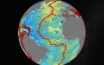
Gravity model of the N. Atlantic; red dots are earthquakes. Quakes are often related to seamounts.
October 2, 2014
This material is available primarily for archival purposes. Telephone numbers or other contact information may be out of date; please see current contact information at media contacts.
Scientists have created a new map of the world's seafloor, offering a more vivid picture of the structures that make up the deepest, least-explored parts of the ocean.
The feat was accomplished by accessing two untapped streams of satellite data.
Thousands of previously uncharted mountains rising from the seafloor, called seamounts, have emerged through the map, along with new clues about the formation of the continents.
Combined with existing data and improved remote sensing instruments, the map, described today in the journal Science, gives scientists new tools to investigate ocean spreading centers and little-studied remote ocean basins.
Earthquakes were also mapped. In addition, the researchers discovered that seamounts and earthquakes are often linked. Most seamounts were once active volcanoes, and so are usually found near tectonically active plate boundaries, mid-ocean ridges and subducting zones.
The new map is twice as accurate as the previous version produced nearly 20 years ago, say the researchers, who are affiliated with California's Scripps Institution of Oceanography (SIO) and other institutions.
"The team has developed and proved a powerful new tool for high-resolution exploration of regional seafloor structure and geophysical processes," says Don Rice, program director in the National Science Foundation's Division of Ocean Sciences, which funded the research.
"This capability will allow us to revisit unsolved questions and to pinpoint where to focus future exploratory work."
Developed using a scientific model that captures gravity measurements of the ocean seafloor, the map extracts data from the European Space Agency's (ESA) CryoSat-2 satellite.
CryoSat-2 primarily captures polar ice data but also operates continuously over the oceans. Data also came from Jason-1, NASA's satellite that was redirected to map gravity fields during the last year of its 12-year mission.
"The kinds of things you can see very clearly are the abyssal hills, the most common landform on the planet," says David Sandwell, lead author of the paper and a geophysicist at SIO.
The paper's co-authors say that the map provides a window into the tectonics of the deep oceans.
The map also provides a foundation for the upcoming new version of Google's ocean maps; it will fill large voids between shipboard depth profiles.
Previously unseen features include newly exposed continental connections across South America and Africa and new evidence for seafloor spreading ridges in the Gulf of Mexico. The ridges were active 150 million years ago and are now buried by mile-thick layers of sediment.
"One of the most important uses will be to improve the estimates of seafloor depth in the 80 percent of the oceans that remain uncharted or [where the sea floor] is buried beneath thick sediment," the authors state.
Co-authors of the paper include R. Dietmar Muller of the University of Sydney, Walter Smith of the NOAA Laboratory for Satellite Altimetry Emmanuel Garcia of SIO and Richard Francis of ESA.
The study also was supported by the U.S. Office of Naval Research, the National Geospatial-Intelligence Agency and ConocoPhillips.
-NSF-
-
Gravity gradient model, Mid-Atlantic Ridge; green dots are earthquakes of at least magnitude 5.5.
Credit and Larger Version -
Brittle stars and deep-sea corals cover a known seamount in the western Pacific Ocean.
Credit and Larger Version -
North Atlantic Ocean gravity gradient model showing plate tectonic history of rifting continents.
Credit and Larger Version -
Gravity model of the Central Indian Ocean; the Malaysian aircraft crashed in this region in March.
Credit and Larger Version -
The researchers' findings are described in this week's issue of the journal Science.
Credit and Larger Version
Media Contacts
Cheryl Dybas, NSF, (703) 292-7734, email: cdybas@nsf.gov
Mario Aguilera, SIO, (858) 534-3624, email: maguilera@ucsd.edu
The U.S. National Science Foundation propels the nation forward by advancing fundamental research in all fields of science and engineering. NSF supports research and people by providing facilities, instruments and funding to support their ingenuity and sustain the U.S. as a global leader in research and innovation. With a fiscal year 2023 budget of $9.5 billion, NSF funds reach all 50 states through grants to nearly 2,000 colleges, universities and institutions. Each year, NSF receives more than 40,000 competitive proposals and makes about 11,000 new awards. Those awards include support for cooperative research with industry, Arctic and Antarctic research and operations, and U.S. participation in international scientific efforts.
Connect with us online
NSF website: nsf.gov
NSF News: nsf.gov/news
For News Media: nsf.gov/news/newsroom
Statistics: nsf.gov/statistics/
Awards database: nsf.gov/awardsearch/
Follow us on social
Twitter: twitter.com/NSF
Facebook: facebook.com/US.NSF
Instagram: instagram.com/nsfgov


